A Weir-d day in the Brindabellas

Saturday 25 June: A weir-d day in the Brindabellas – L/E-M. A number of small weirs were built on the eastern flanks of the Brindabella Range in the 1960-70s. We visit several of them, walking mainly on Old Mill Rd and Warks Rd management trails except for short forays through the bush to each weir. There is a short 200m across the ground and nearly 100m vertical plunge off the Bulls Head Range to save walking an additional 3km of fire trail. Of course, there is a geocache at each weir. Around 20km and 500m climb. The walk is at 800-1200m altitude, with possible snow above 900m. Maps: Tidbinbilla and Cotter Dam. Leader: John Evans 0417 436 877 john@johnevans.id.au . Transport: ∼$15 per person.
6 of us drove in 2 SUVs to the junction of Brindabella Road and Old Mill Road.
Summary
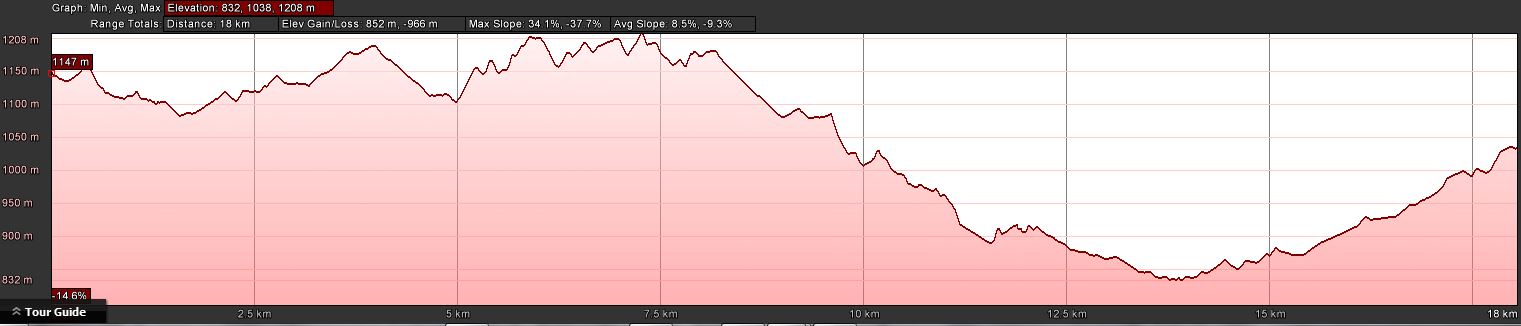
Distance: 18.5km | Climb: 850m | Time: 8.40am-2.45pm (6hrs 5mins), including 40 mins of breaks | Grading: L/E-M; H(12)
Photographs
Photographs are available, where you can start a large sized slideshow.
Video
Waypoint and Track Files
Download the .gpx file. (Right click, Save Link As…, Save – if you want to use it.)
To use in Google Earth, do File, Open… and select Gps or All files as the File Type.
Track Notes
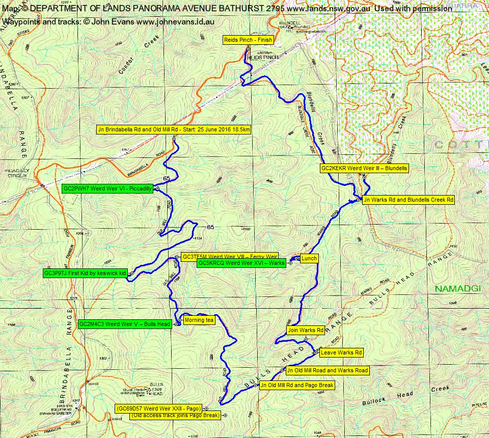
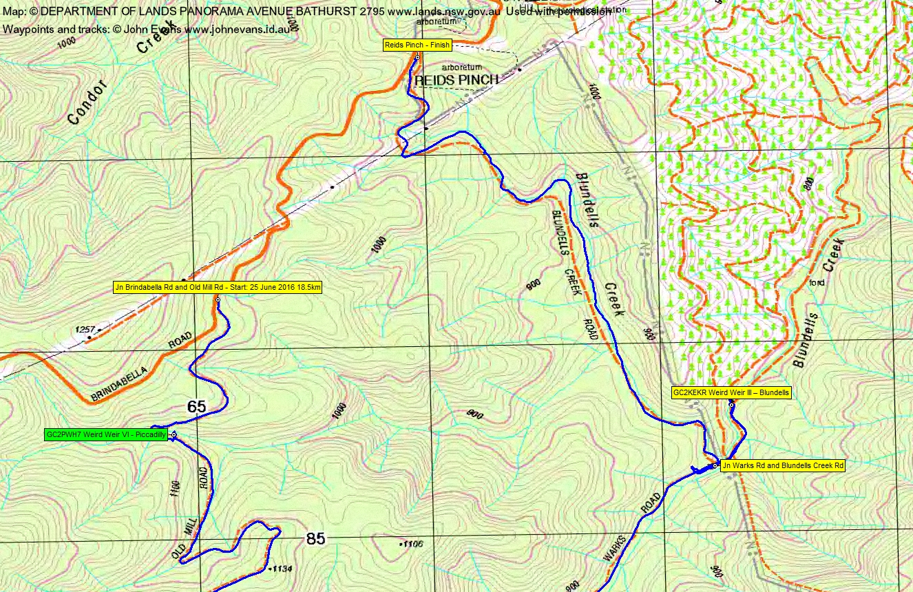
The plan was to walk from Reids Pinch (the Namadgi National Park sign at the intersection of Brindabella Road and Blundells Creek Road), but the road was nice and crisp with the cold morning following the dusting of snow so we drove on up to the intersection with Old Mill Road, then dropped a car back at Reids Pinch.
An absolutely glorious day! Some light snow on the ground and in the shrubs and trees most of the day, a clear blue sky and not a breath of breeze!
We wandered down Old Mill Road to Piccadilly Weir. Roger was the first to head down through the snow-encrusted scrub to the weir. Two of us followed and got a couple of wet feet crossing the merrily flowing stream to the other side. Down to the weir, only to find that Eric had walked across. Collected the clues, retraced our steps and found the final GZ to log the cache GC2PWH7 Weird Weir VI – Piccadilly. Of course the published waypoints and track do not show the final GZ.
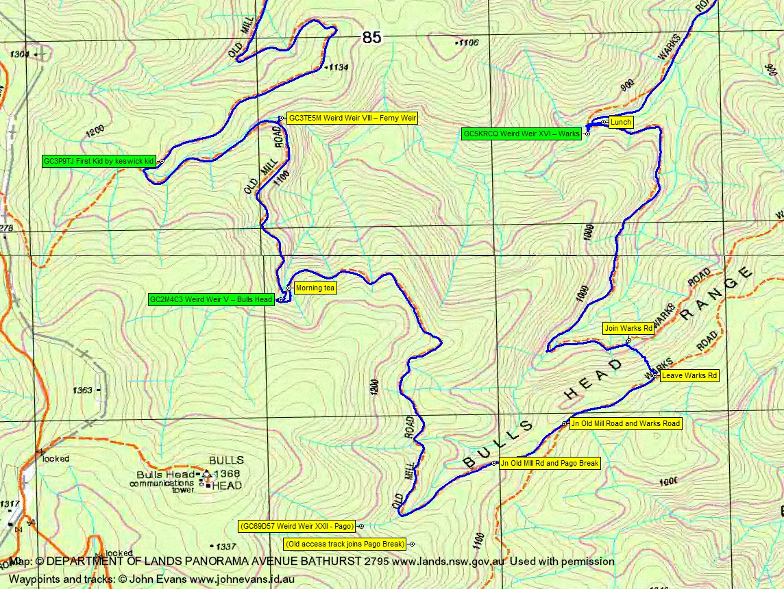
Gently up to near SH1134, a little more up along Old Mill Road for muggle Denis to find GC3P9TJ First Kid.
Around a kilometer later we headed down off the road to Ferny weir and GC3TE5M Weird Weir VIII – Ferny Weir. Again the clues were collected and calculations for the single-step multi made. The final GZ was back up along the way we’d come in (or else a shorter distance through the snow-ladened scrub). An executive decision was quickly made to return in spring!
A further kilometer south along the management trail and through lovely snow-dusted country we came to a bend in Old Mill Road with Bulls Heads weir towering above us. We all ascended through the scrub close to the creek to the weir. Now I’m not a well organised geocacher. This time I’d printed all the cache listings and the spoiler pic for this cache – but left them in the car 🙄 . We searched for some time for GC2M4C3 Weird Weir V – Bulls Head. At last Denis again came to the fore and made the find, saving my bacon. So a log. Heading back down, we found the benched construction track so took that. Eric looks quite snow-ily happy in the photo leading us down. Grabbed our packs and found a patch of sun on the road for morning tea.
Another couple of kilometers east, south, then north-east saw us at the junction of Old Mill Road and Pago Break. Now, I don’t often provide options for party members to choose, but here did. My bung knee was playing up a bit and I hoped that they’d choose the softer option. So I made the trek up Pago Break and the rough route into Pago weir sound very difficult, and talked up the softer option of continuing down to join Warks Road. Thankfully my good friends chose the latter.
So we joined Warks Road at the ‘Old Mill Rd’ post and headed down it for a couple of hundred metres. Here there was the option to plunge down off the side of the Bulls Head Range for a short distance, or to walk 3km down the fire trail to a u-turn and back to the same point. We chose the short plunge and it turned out to be relatively easy going. However, it did show me that whilst I can currently walk fire trail, my knee is not ready for down hill off-track stuff.
The snow thinned as we dropped from 1000 to 900m. It was an easy enough few metres in off the road to Warks weir and geocache GC5KRCQ Weird Weir XVI – Warks. A few stinging nettles about. Cool in the shade at this corner and we back up the road a bit to a patch of sun for lunch.
Another kilometer or so we came to the junction of Warks Road and Blundells Creek Road. Continuing along Warks Road we passed the signed intersection with Pago Break (must explore that one day) and so to Blundells weir. Plenty of water in this creek too, as with all the others. A quick foray to the weir, then a not so quick collection of clues and an even poorer amount of calculation. We got something and went for a look for the final GZ, but no go. Will have to throw ourselves on the mercy of the cache owner.
Walking back up Blundells Creek Road we passed a couple of guys walking down, then another. A couple of cars up near ours.
We collected the other car and drove home, the road a bit sloppier and muddy and a lot more traffic about. I left half the Brindabella Road dirt and slop at the car wash after high pressure hosing out the wheel arches and bottom of my car.
A lovely day. I think everyone enjoyed it.
Track Maps
Track overview
Track 1
Track 2
Profile
Party
6 walkers – Roger E, Vin F, Eric G, Denis G, Annette M, me.
Terrylea
26 June , 2016 8:41 amJohn. Airways love reading your trip notes. You are a real wag. What a hoot and what’s that? Your knee wasn’t quite ready for the steep downhill just yet – hmmm – really? Take care of that knee a little longer and it’ll be take care of you for years to come. I really would have loved to have been on that walk with you. Looks stunning. Am keen to get into geocaching too one day. Stay warm today. Hikergirl (aka Terrylea) ?
Johnny Boy
27 June , 2016 11:42 amHey Hikergirl – you had a great walk too! Thanks for the advice 🙂