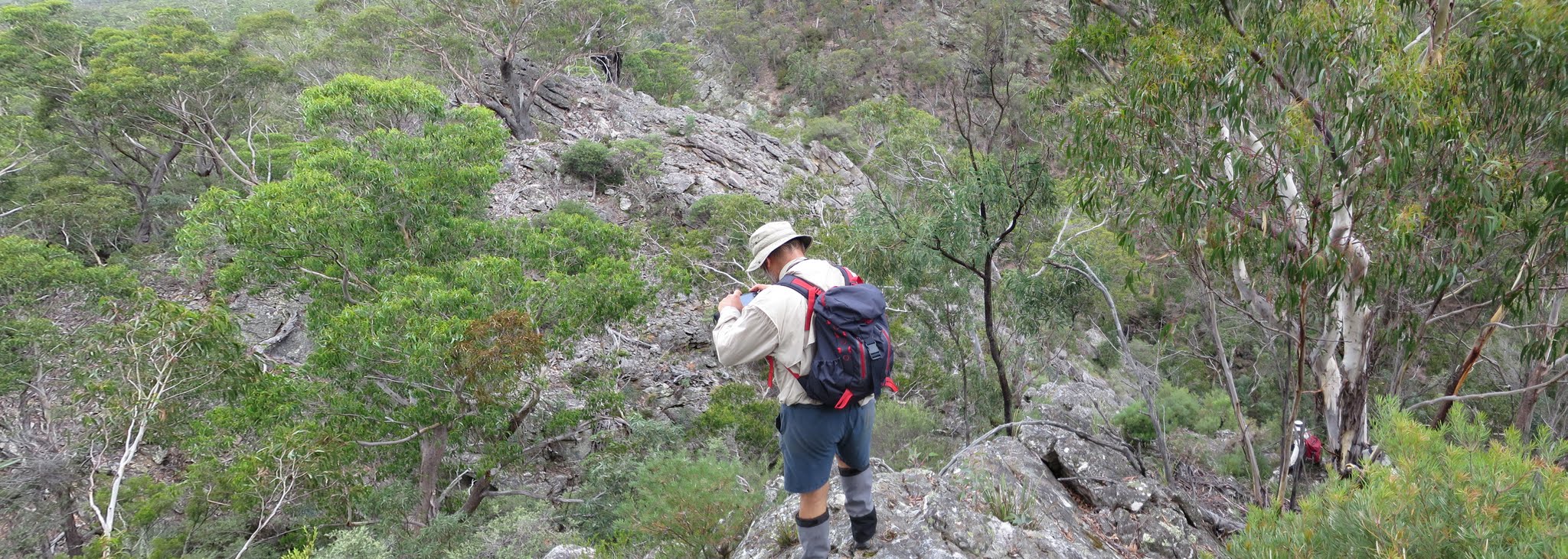
Rocky top of the descent to Parliament Creek
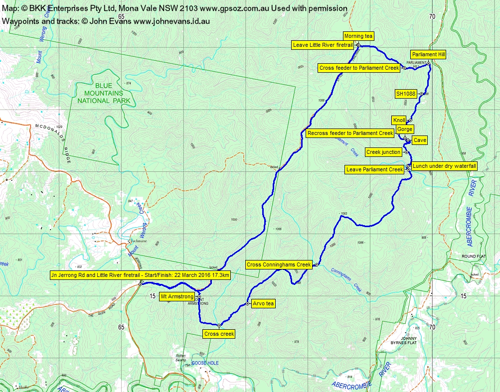
Tuesday 22 March: Parliament Hill, Blue Mountains National Park – L/R/X. The walk starts at the junction of the Little River fire-trail and the Jerong Road, 34 km northeast of Taralga. This is a new area for the leader. We will follow the fire-trail north for 6 km then head off-track for the day. We will climb Parliament Hill and explore the woodlands and forests in the catchments of Parliament Creek and Conninghams Creek. This is a long day, with numerous ascents and descents. There is a 2 hour 35 minute drive each way. Minimum distance: 16 km with 850 metres of ascent. Map: Mount Armstrong. Leader: Ian W. Transport: 371 km return. Limit: 8.
4 of us drove in 1 vehicle to the park at the junction of Jerrong Road and the Little River Fire Trail. A 2hr 30min trip.
Summary
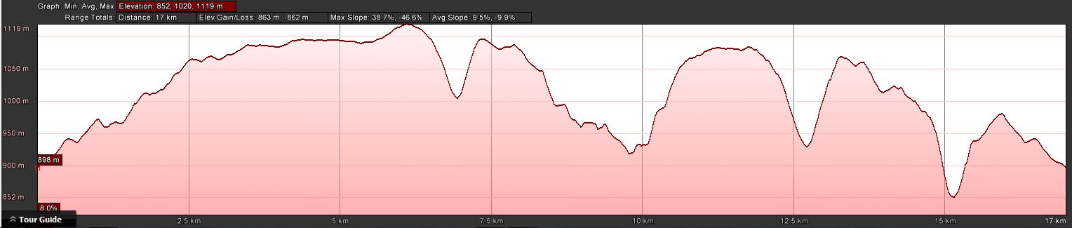
Distance: 17.3km | Climb: 860m | Time: 8.40am-4.10pm (7hrs 30mins), including 45 mins of breaks | Grading: L/R; H(13)
Photographs
Photographs are available, where you can start a large sized slideshow.
Videos
Waypoint and Track Files
Download the .gpx file. (Right click, Save Link As…, Save – if you want to use it.)
To use in Google Earth, do File, Open… and select Gps or All files as the File Type.
Track Notes
A long day, 14 hours door-to-door from my place in north Cooma (Gordon). Huge thanks to Ian W for driving and leading!
The scenery did not start well, with a 6.1km in 1hr 15mins fire trail bash along the Little River Fire Trail. Morning tea was called.
Things improved a little as we went bush to the east, down then up to Parliament Hill. Nice walking in dry forest with little impediment underfoot. Things went downhill at Parliament Hill, not very impressive at all.
The next leg was south along a ridge to SH1088. Some nice rocky bits in one place. Then slightly west of south and down to a knoll. Views west to the ridge we came in on. And so down to recross the feeder creek to Parliament Creek.
Soon after things improved dramatically! High above the feeder creek on the true right bank we looked down a fair way into a gorge. Progressing a little, we spied a large overhang/cave in the other bank of the creek, so carefully made our way to the creek and doubled back up to sus out the cave and dry waterfall. The photos and videos tell the story. A great find. Continuing down the creek, we came to another large drop with pools of water. Parliament Creek came in from the west. Above the junction there was a fine rocky area (check out the video) and a steep descent to Parliament Creek. Here we found yet another dry/just trickling waterfall with a pool at the bottom. A great lunch spot (check out the video).
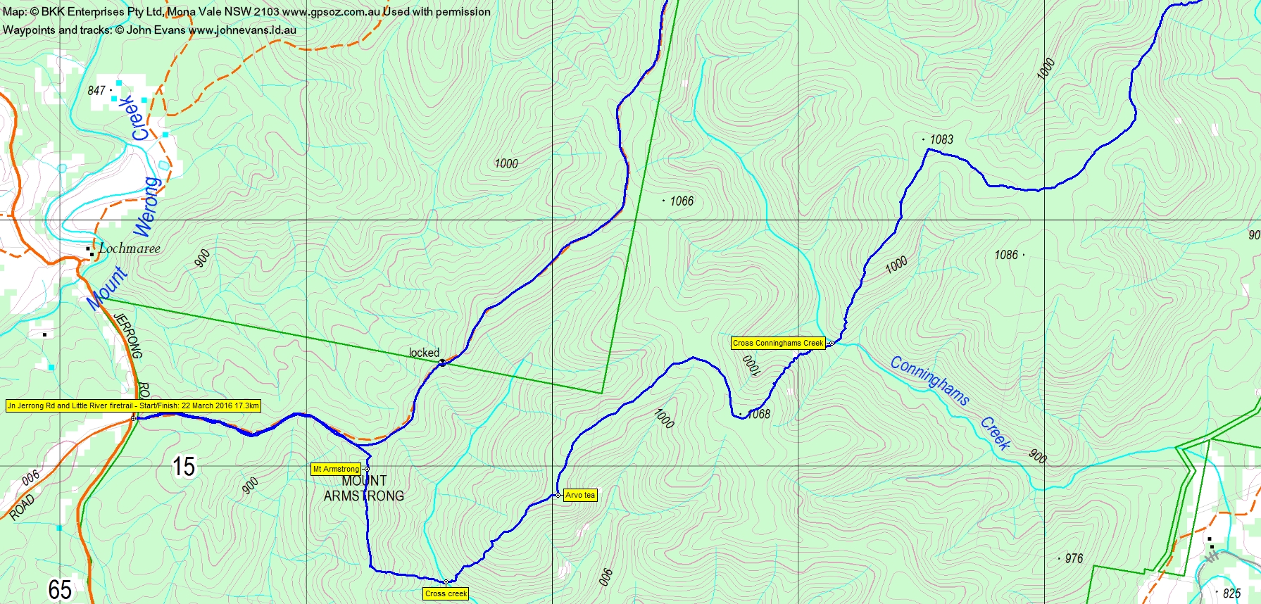
We left Parliament Creek and endured an initially very steep 170 vertical metre climb up to the next ridge system. Easier walking as we looped round to near SH1083. Now it was steeply down 180 vertical metres to cross Conninghams Creek.
A 150 vertical metre climb out of that creek to wander across yet another ridge system, then along and more gently down to arvo tea.
A final steep 170 vertical metre descent to cross another creek, then the final up to Mt Armstrong. This feature equally as unimpressive as Parliament Hill. We popped out onto the fire trail and back to the car.
Dodged to multitudinous macropods on the way out to the sealed road.
A walk of humble beginnings that turned out to have some great features. Always good to walk in a new area, even if it is so far from home. Pleasant to not have to push through scrub too. Thanks Ian!
Timings
| From | To | Distance | Time |
| Start | Morning tea | 6.1km | 1hr 15mins |
| Morning tea | Parliament Hill | 1.3km | 36mins |
| Parliament Hill | Recross feeder creek | 1.4km | 36mins |
| Recross feeder creek | Lunch | 1.2km | 55mins |
| Lunch | Cross Conninghams Creek | 2.9km | 1hr 25mins |
| Cross Conninghams Creek | Arvo tea | 1.8km | 45mins |
| Arvo tea | Finish | 2.6km | 1hr 5mins |
Track Maps
Track overview
Track 1
Track 2

Profile
Party
4 walkers – Eric G, Ian H, Ian W (leader), me.
Next Tuesday Walk
Tuesday 29 March: Geocache McKeahnie in the Middle – L/R,ptX. Insert via the Square Rock Walking Track, then off-track through dense regrowth to McKeahnie Trig. Further south along the crest gets us to a knoll hiding the geocache GC245R6 McKeahnie in the Middle. Return via a sidle east of the trig. Pick up GC184R1 Orroral Overview at the Orroral Lookout. Around 16km and 550m climb. Map: Corin Dam. Leader: John Evans 0417 436 877 john@johnevans.id.au . Transport: ∼$8. Limit: 8.