Stingray Swamp Flora Reserve

Tuesday 21 February: Penrose State Forest – L/R/X. The forest is located about 20 kilometres northeast of Marulan. Most of the forest is a pine plantation but there are areas of native bushland and wetlands. We’ll follow forest tracks and creeks, visit the Stingray Swamp Flora Reserve and traverse the base of a small cliff-line which may require some rock scrambling. Off Track: 13 km, On Track: 7 km. 1 hour 40 minute drive each way. Bookings by the Friday night before. Distance: 20 km with 450 metres of ascent. Maps: Canyonleigh, Wingello. Leader: Ian W. Transport: 320 km return. Limit: 8.
Further Information
A long drive of around 2hrs 15mins from Weston Creek, but well worth it.
Summary
Distance: 21.2km | Climb: 480m | Time: 8.40am – 4.20pm (7hrs 40mins), including 45 mins of breaks | Grading: L/R; H(12)
Photographs
Photographs are available, where you can start a large sized slideshow.
Videos
Waypoint and Track Files
Download the .gpx file. (Right click, Save Link As…, Save – if you want to use it.)
To use in Google Earth, do File, Open… and select Gps or All files as the File Type.
Track Notes
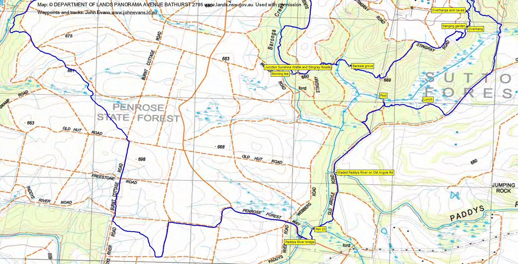
We set off along Webbers Rd, with pine trees on one side and quite inviting looking native forest on the other.
Around 1.3km along we struck off into the native forest, down and through a dry Baronga Creek and up the other side. This finger of bush revealed the walk’s first secret surprise – a nice little (map marked) cliff-ette. We followed along the base for a little while, the sandstone eroded into weird shapes.
We climbed to the 700m feature and on its SE side saw our second secret surprise – a rocky head with a bird’s nest in its single eye. The head took on quite a different shape as we passed around and under it.
Between our several surprises we were happy to endure a little fire trail. We popped out onto Sunshine Wattle Road and followed it above the true left bank of Baronga Creek. A rather flat looking snake gave us a real surprise! Sick of the fire trail, we again descended to see what the going was like in Baronga Creek. It was not too pleasant so we contoured above the creek to morning tea.
Away again, a short ascent had us at the junction of Sunshine Wattle and Stingray Roads, again between pine and native forest. There was some tall timber.
A few hundred metres along Stingray Rd we again went bush and found our next secret surprise – a finger of Stingray Swamp Flora Reserve. Lush green low ferns. Climbing towards SH689 we passed through a banksia grove and some light, dry native forest.
The Spot Height was encircled on the west and south by another small cliff and the colours of the sandstone provided our next secret surprise. There was a distant open view to the south and east from the top.
We followed an old logging track to rejoin Stingray Road, which we tromped for 550m. We turned down into the bush, heading for what Ian thought might be a small cliff line that he’d spied on Google Earth, but not map marked. This was to be our major secret surprise for the day!
The cliff line first presented the problem of getting down to its base and a short SW detour was required to find an entry point. As we walked along the base, the height of the cliff grew and its features came thick and fast. Lovely sandstone sculptures, an overhang, a hanging garden, more overhangs and caves and a final huge overhang. Wonderful scenery hidden away in a pine forest.
We crossed to the next drainage line and walked south along the base of the map marked cliffs. At the southern end we enjoyed the last of the cliffs, then headed SW to the boundary of the State Forest and the Flora Reserve. We crossed Stingray Swamp again, through verdant grasses.
A bit further south we joined Old Argyle Road and walked it for 700m. Turning back down to the edge of the swamp, we found lunch.
Another expected secret surprise west of lunch where Ian had marked a ‘pool’ waypoint. A little tannin-coloured today, but obviously a swimming hole as there was a rope swing across the other side.
A couple of short fire trails had us back on Old Argyle Road, which we followed for 1.2km. It included a wade of Paddys River with what looked very much like bamboo lining the ford. Yet another swamp crossing and we were out onto Penrose Forest Way and crossing the Paddys River bridge.
Our homeward leg from here included a little gratuitous distance and was not as interesting as the morning part of the trip. But it had its moments. We continued up Penrose Forest Way beside harvested pines. It looked a little desolate. Some zigs and zags on minor fire trails. It was warm in the beating sun. Then a nice diagonal through a block of mature pines to join Paddys River Road- Burnt Cottage Road. Along it for a couple of blocks.
At the corner of Burnt Cottage Rd and Old Hut Rd we could see the former stretching into the distance, so Ian took us on another off-track though pine forest leg to the NW. Dark and dead in this pine forest, but soft needles on the ground made pleasant walking.
We touched on Hanging Rock Swamp to see what was there, then walked Hanging Rock Swamp Road for a while.
A final cross of a swamp and off-track, through pine forest return to the car.
Another feature rich walk planned by Ian in a new area. Hats off to him yet again. (And for driving, while I slept up and back.)
So, as you drive the Hume Highway and see the Penrose State Forest signs the next time, know that it’s not all dull off the highway.
Track Maps


Party
4 walkers – Eric G, Meredith H, Ian W (leader), me.