
Chalkers Chimney
Sunday 18 May 2025: Adventures in the Southern Namadgi * L/E-M. From the Mt Clear campground, walk the Long Flat Fire Trail to the southernmost point of the ACT. Along the way we’ll visit some interesting sites including Potters Chimney, Sam Abouds dunny, Chalkers Chimney, and border markers and blaze trees on the southern border of the ACT. Long Flat is an open valley surrounded by timbered country. A 1 hour trip of 55km each way, including 12km of good bad dirt on the Boboyan Rd. The hike is around 22km and 650vm, primarily on fire trail with short forays into the bush.
Summary
From Garmin Connect (recorded on Epix Gen 2) – Distance: 22.09km | Climb: 590vm | Time: 4:46 moving + 1:18 of stops = 6:04 | Grading: L/M; M(11).
Photographs
View photographs here.
gpx file
Download the gpx file here.
Track Map
Here’s where we went:

Track on Topoview2006 NSW mosaic

Most of the track on current Bredbo October 2022 1-2500 topo map from SIX
Trip Report
Today’s take-a-ways:
- The Boboyan Road dirt is in horrible condition – much of it down to rocky base level, corrugated. Thanks to the two boys with big 4WDs who transported us
- Last day today after which NNP East is closed 19-31 May for thermal imaging feral pest control
- Weather was cold and windy. A bit of mizzle on the way down and we beat any showers back to the vehicles
- Old codger’s lament – I was 60 years older than the youngest in the party. Suffering 20 stitches in my back, thanks to others who carried a bit of my gear.
I was last down this way on 13 Oct 18.
We were walking by 8.35am and took the shortcut directly over to Potters Chimney.

Potters Chimney
We then crossed over Back or Grassy Creek to gain the Long Flat Fire Trail. Along it and up the zigzags. We called in at the vestigial stockyard just off the fire trail. (I know nothing of its origins, although the barbed wire style is not really old.)

Remnant stockyard beside Long Flat Fire Trail
On to Edward Brayshaws Hut site.

Edward Brayshaws Hut site
This is where Sam Aboud built his shed and famous dunny, a “loo with a view”.

Sam Abouds dunny
A bit further down the fire trail we headed off handrailing the creek to Chalkers Chimney.
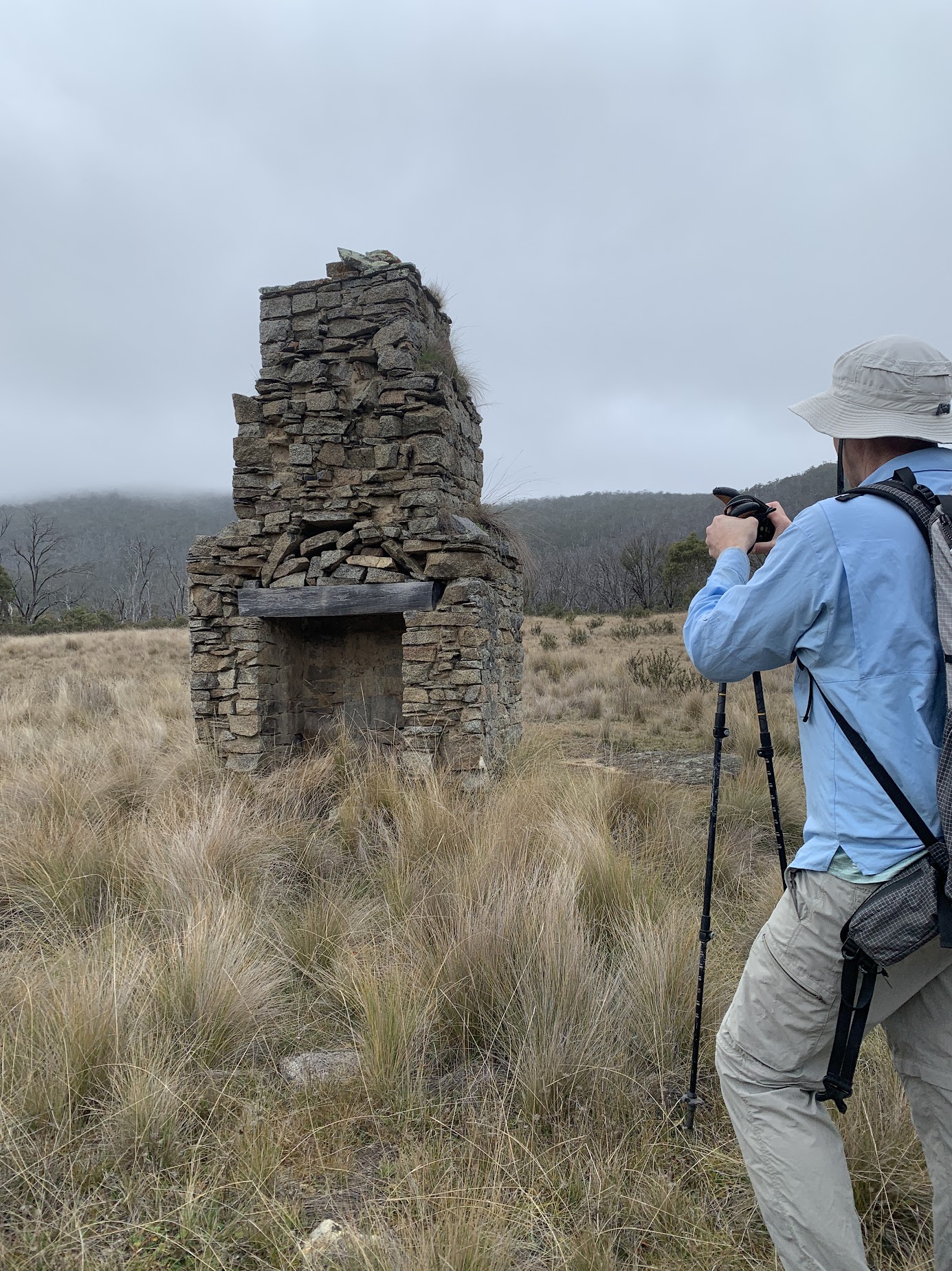
Chalkers Chimney
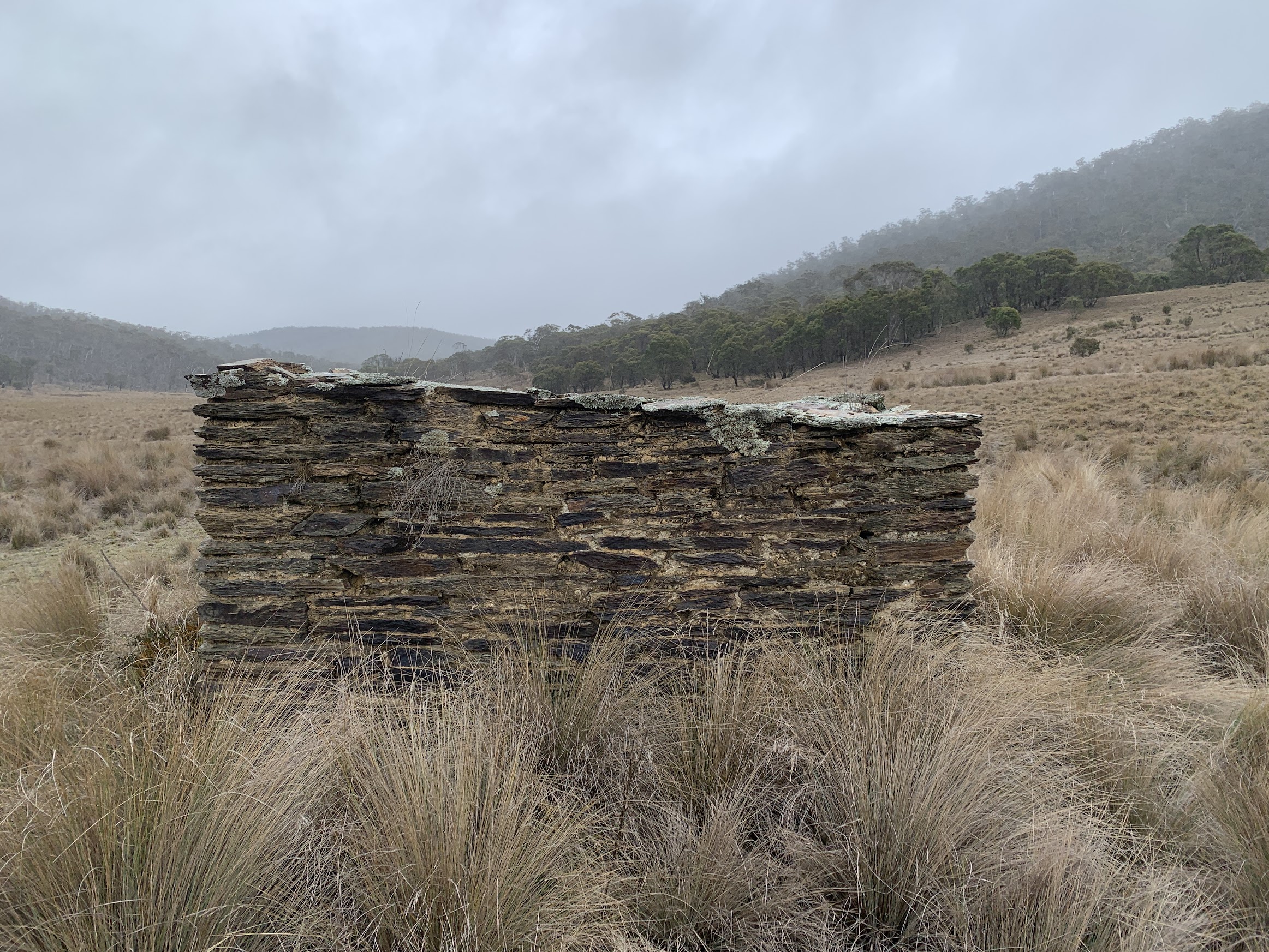
The Chalkers Hut site is immediately behind the chimney.
Chalkers Hut site
Chalkers Stockyard site is around 50m further on from the chimney.

Chalkers Stockyard site
Our return was a little higher up from the creek line, through open woodland. A stop for smoko on the way, out of the wind as much as we could.
Rejoining the Long Flat Fire Trail I was probably talking too much and missed the turn off down Long Flat. No matter, as the plan was to use both the old and new Long Flat Fire Trails. The new route takes traffic away from Long Flat and should certainly be used if you are MBT riding. It wiggles a little to the SW, eventually joining the ACT border fire trail.

Southern junction of ‘new’ Long Flat FT and ACT border FT
We followed the border fire trail to the SE. I had several border markers and blaze trees in my GPS, just can’t resist. It’s been 15 years since I hunted border markers through here, on 20 Nov 10. We visited a few of the markers, including L39.

Border marker L39
Unfortunately, all the associated blaze trees seem to have gone (or I didn’t spend enough time searching for them – I don’t like to bore party members).
We spotted markers J39, G39 and E39. Photos in the album if you are a border marker aficionado.
Our furthest objective was the southernmost point of the ACT. It’s marked by border marker C39 and I spent most of the lunch break looking for it. Reports from others visiting this area over the last year or so have reported a no find. I’m 70% confident that we spotted it.

Border marker C39, no blaze – southernmost point of the ACT
Here’s my evidence.
So it was all over bar the shouting, and our return along Long Flat.
This end of Long Flat is signposted as Long Corner FT Link.

South junction of ‘new’ and old Long Flat FT
Immediately onto softer going underfoot.

Heading N at the start of the old Long Flat FT
As the timbered area ended, we broke out onto Long Flat.

Breaking out onto Long Flat
It was still pretty cool and windy.

A cool huddle on Long Flat
Quite a lovely area, a long time frost hollow I’d guess.

Long Flat
Only spoilt be the pig rooting.

Pig damage on Long Flat
Rejoining the fire trail, I realised why I missed this junction on the way in.

North junction of ‘old’ and new Long Flat FTs
A quick leg of 7.1km in 1:27 back to the cars, beating the showers.
The back of Potters Chimney as we just beat the weather back
Just as we were leaving, A Ranger arrived to put NNP closure notes on the other vehicles still there and close off the road into the parking area from the Boboyan Road.
Thanks for your company friends. Several had not visited this area before, so I hope you enjoyed it.
The AllTrails map is here, where you can pan and zoom.
Party
8 walkers – Anna G, Kirk H, Stephen J, Karina J, Ming L, Kiko P, Jaime P, me.