View into the second gully from 1100m contour
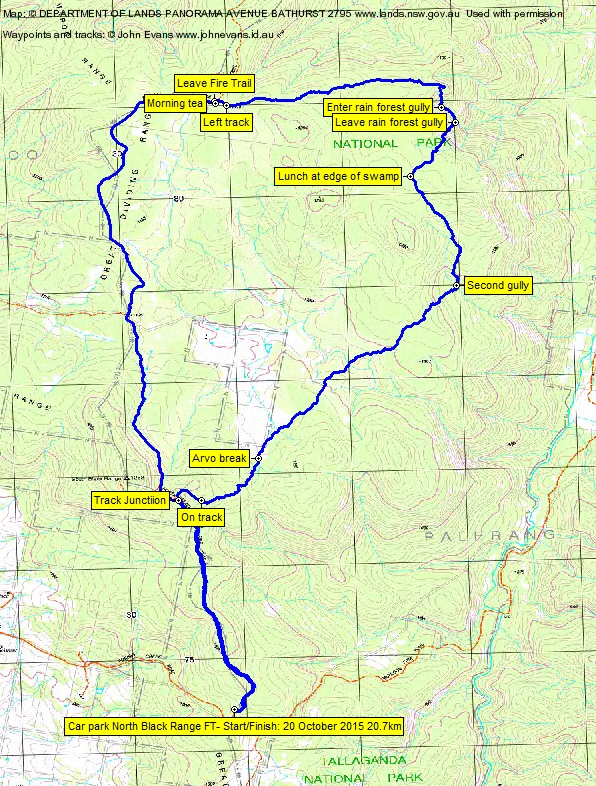
Tuesday 20 October: Tallaganda National Park – L/R/ part X. The walk is in the northern section of Tallaganda National Park. From the junction of the Forbes Creek road and the North Black Range fire trail, we follow the Black Range fire-trail for 8 km, then walk off-track for most of the day. We will take a long meandering route east then southwest, through forests, swamps and rocky, undulating ridge country back to the cars. This is a long exploratory trip with steep and scrubby ridges in places. Minimum distance: 20 km with ∼600 metres of ascent. Map: Bombay. Leader: Ian W. Transport: 106 km return. Limit: 8.
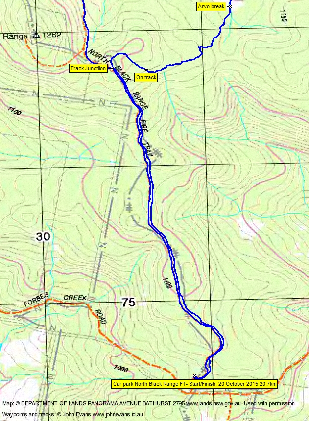
5 of us drove in 2 vehicles via Queanbeyan, Kings Highway, Captains Flat Rd, Briars Sharrow Rd, Plains Rd, Hoskinstown Rd through Hoskinstown and Forbes Creek Rd to the car park a couple of tens of metres from the junction of Forbes Creek Rd and the North Black Range Fire Trail. Around 1hr 15mins from Woden.
Summary
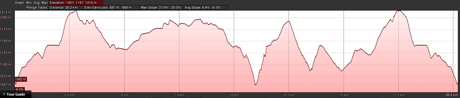
Distance: 20.7km | Climb: 660m | Time: 8.00am-4.10pm (8hrs 10mins), including 60 mins of breaks | Grading: L/R; H(12)
Photographs
Photographs are available, where you can start a large sized slide show.
Waypoint and Track Files
Download the .gpx file. (Right click, Save Link As…, Save – if you want to use it.)
To use in Google Earth, do File, Open… and select Gps or All files as the File Type.
Track Notes
Tallaganda National Park provides the best dry sclerophyll forest walking within easy reach of Canberra. Today’s area had magnificent Brown Barrel and White Ash light forest. Underfoot was mostly open, but with some fallen timber. Dianella (Purple Flax Lily) predominated, but little of it was in flower. However, the ground was quite rocky and uneven, and we all found that concentration was required. Our ankles had a good workout. Several damper areas had Lawyer Vine (Smilax australis) and the narrow rain forest gully contained Tree Ferns (Dicksonia antarctica) and plenty of healthy Stinging Nettle (Urtica incisa).
The morning was mild with scattered cloud as we set off north along the North Black Range Fire Trail, wondering if we could have driven it (perhaps yes, in dry conditions, with a high clearance vehicle for the stones at the top of one small slope). An uneventful 8.4km in 1hr 40mins to morning tea at our go bush point.
A small track took us just 100m in from morning tea, where we had to leave it as it was not heading our way. The eastern leg took us gently down (the vertical scale on the track profile is quite large) through going as described above. It terminated at a granite knoll/slab which hinted to the east at the 300m drop to Mulloon Creek. To the south-east there was a slightly more open view with glimpses across to Mt Palerang.
We exited the granite to the south and descended into a rain forest gully. Narrow in extent, it struggled to establish its ecosystem. But there were nice Tree Ferns, Lawyer Vines with excellent spring growth, and thigh-high Stinging Nettle. I don’t mind a brush with the latter, because it makes you know that you are alive for the next 30 minutes. Shorts are the perfect dress for such an encounter.
A bit of a puff to exit, climbing 100m in 200m across the ground. Coming up, two of us walked by a Greater Glider (as revealed by subsequent internet research) in a crack between rocks. It exchanged loud growls for a photograph with another party member.
The gradient once again became more gentle and we headed south-west to our lunch spot on the edge of a high-altitude (1160m) swamp. More encounters with the fauna of the region, with a very small leech picked off a leg and us feeding the mosquitoes on their first taste of human blood.
Since leaving the Fire Trail after morning tea we’d covered only 3.9km in 2hrs 20mins, mainly due to the slow rain forest gully. So during lunch our gallant leader planned a few corner cut options to have up his sleeve.
But we continued south-east as planned to a second gully to have a look. It was broader and dryer, and a good pace was maintained.
Exiting from it, we turned south-west via gentle up then down, across a major feeder creek to Mulloon Creek, then down across open flats to the corner of a private property block. Just south from there our sensitive leader asked if we had any tucker left and if we wanted an arvo tea break. We did. Comments on the amount of water we’d consumed on, probably where we were, a max 24ºC day.
Nearly all over bar the shouting, except we couldn’t find a point on a previous trip’s track end in the area. Found a couple of hundred metres later, which took us in an arc back to the North Black Range Fire Trail. And so back to the cars.
A good day. Lovely forest. Concentration needed for the rocky ground, but generally open dry forest except for the rain forest gully. Thanks Ian and friends. Happy that I coped and that my recent layoff didn’t sap too much of my condition.
Timings
| From | To | Distance | Time |
| Start | Morning tea | 8.4km | 1hr 40mins |
| Morning tea | Eastern edge | 2.3km | 1hr 5mins |
| Eastern edge | Lunch | 1.5km | 1hr 15mins |
| Lunch | Arvo break | 4.5km | 2hrs 10mins |
| Arvo break | Finish | 3.9km | 1hr 5mins |
Track Maps
Track overview
Track 1
Track 2

Track 3

Profile
Party
5 walkers – Roger E, Eric G, Ian H, Ian W (leader), me.
Next Tuesday Walk
Currently no Tuesday walk 27 October.
Details to come for Tuesday 3 November.