South Arm of Middle Creek

Tuesday 2 June: South Arm of Middle Creek – L/R,ptX. Walk over the Gudgenby grasslands into the mouth of Middle Creek. Follow the south arm of Middle Creek up to a knoll, around half way to Bogong Gap. There’s a geocache there. Cross to the north side of the creek for another geocache, sidle to the Burbidge spur and wander back. Some good granite. Around 15km and 500m climb. Maps: Rendezvous Creek and Yaouk. Leader: John Evans 0417 436 877 john@johnevans.id.au . Transport:∼$15 per person. Limit: 8.
7 of us drove in 2 cars to the Yankee Hat car park.
Further Information
Geocaches CG2RX5M Abort, Abort! and GC5T5X5 Abort! Abort! II.
Summary
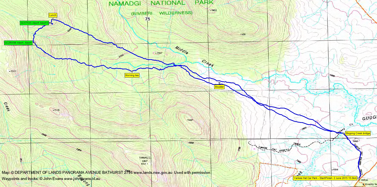
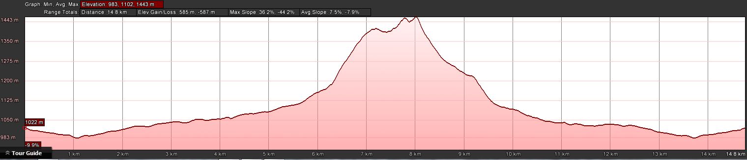
Distance: 15.0km | Climb: 585m | Time: 8.30am-3.10pm (6hrs 40mins), with 40 mins of breaks | Grading: L/R,ptX; H(12-)
Track Maps
Track overview
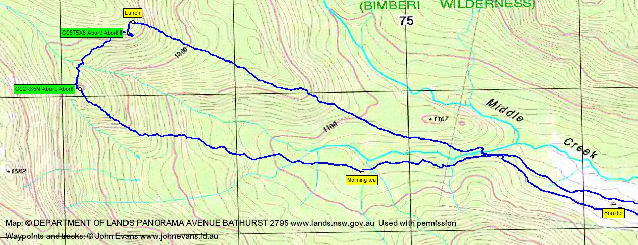
Track 1

Track 2
Profile
Photographs
Photographs are available, where you can start a large sized slideshow.
Waypoint and Track Files
Download the .gpx file here. (Right click, Save Link As…, Save – if you want to use it.)
Download the .kml file here.
Track Notes
A cracker of a winter’s day, starting with a -5ºC morning in Canberra. But a cloudless blue sky and not a bit of breeze. A couple of patches of snow on the road as we drove out.
A nice wander across the Gudgenby grasslands into the mouth of Middle Creek, passing the huge boulder marked on the Rendezvous Creek map with an *. A few scratchy patches as we turned west and paralleled the true right side of the south arm of Middle Creek, but also many animal pads to follow. Morning tea was called just before 10am, after covering 5.2km in 1hr 20mins.
We ran into snow on the ground at the bottom of the 300m climb to the knoll where geocache CG2RX5M Abort, Abort! was located. A little damp, with melting snow falling from the taller bushes. Great views back down to the grasslands as we climbed and a huge view up to Mt Burbidge from the knoll. A quick search revealed the cache. This leg 2.0km in 1hr 10mins.
From here we needed to cross to the bouldery and snowy other side of the arm of Middle Creek. It was sunless and more snowy down at the creek and a little tricky to cross.
Easier, but still snowy, going as we climbed up from the creek line. Some nice icicles dripping from granite. The second geocache, GC5T5X5 Abort! Abort! II, was also a quick find. A joint FTF (first to find) with Marmaduke Rothschild.
From there, we climbed towards the crest of the Burbidge spur to try to find some sun for lunch. First cache to lunch was 1hr 5mins to cover 900m across the ground.
The homeward leg continued to be snowy, nearly until we reached the grasslands. The Burbidge spur remains a bit scrubby, although there are animal pads and footpads (a little hard to follow in the snow) in the lower parts. Lunch to cars was 6.8km in 2hrs 20mins.
A top day for the cachers and, I hope, a satisfactory day for the others.
Party
7 walkers – Roger E, Eric G, Meredith H, Ian H, Stewart J, Ian W, me.
Next Tuesday Walk
Tuesday 9 June: Bungongo State Forest – L/R,X. Bungongo State Forest is located between Wee Jasper and Jugiong. This is a new area for the leader. This is a long exploratory walk, in native forests and woodlands, with numerous ascents and descents. The walk starts near the western end of the forest and is mainly off-track in the catchments of Parsons and Old Jeremiah Creeks. There is a 2 hour 15 minute drive each way. Minimum distance: 18 km with 900 metres of ascent Maps: Adjungbilly, Wee Jasper. Leader: Ian W. Transport: 400 km return. Limit: 8.