Lake Burley Griffin from above Parkes Way

Saturday 2 January: Cbr100 training – Cbr100 25km route – L/E. Walk the Cbr100 Challenge 25km route. Campbell High School, Anzac Parade, Commonwealth Avenue bridge, Melbourne Avenue, Red Hill, Kent St, Dunrossil Drive, Scrivener Dam, southern flank of Black Mountain, West Basin and back to the start. Details at http://www.cbr100challenge.com.au/25km/ . Around 27km and 620m climb. Map: Canberra. Leader: John Evans 0417 436 877 john@johnevans.id.au . Transport: Drive yourself to an 8am start at Campbell High School. Please book.
4 of us met at Campbell High and a fifth joined us at 10km.
Summary
Distance: 29.9km | Climb: 720m | Time: 8.05am-3.30pm (7hrs 25mins), including 25 mins of breaks | Grading: L/E; H(12-)
Photographs
Photographs are available, where you can start a large sized slide show.
Waypoint and Track Files
Download the .gpx file. (Right click, Save Link As…, Save – if you want to use it.)
To use in Google Earth, do File, Open… and select Gps or All files as the File Type.
Track Notes
First serious training for the Cbr100 on 5-6 March. I only just coped today (sore balls of feet), so I have a bit to do. Lost half the party on Red Hill at one stage and lost the track on the flank of Black Mountain, so really should be reported to the CBC Walks Secretary.
But 6 geocaches and, as all commented, we walked for 25km in the centre of Canberra and actually passed very few houses. We are very blessed to be living in the ‘Bush Capital’ with so many walking options and facilities. Many other walkers, runners, bikers, dragon boat paddlers, rowers, sailors, roller bladers out.
Pleasant walking with cloud cover and a max of 28ºC today. Just got back to the cars as drops from a short, sharp rain band caught up with us.
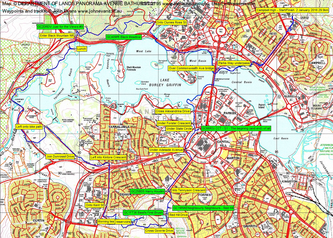
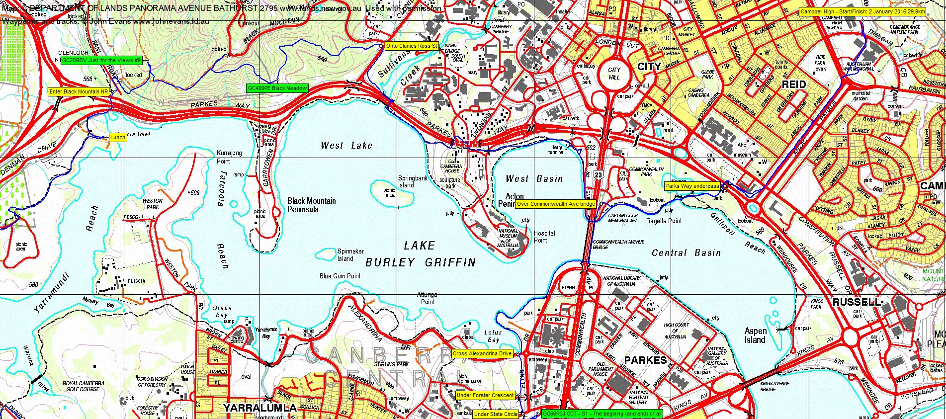
A straight forward start, down past the Australian War Memorial and the new Bushmaster vehicle recently positioned there. Down Anzac Parade past the evocative memorials, round the corner of the still-unoccupied art deco building and under Parkes Way into Commonwealth Gardens.
Down to the edge of Lake Burley Griffin, around to Commonwealth Avenue bridge and over it, then up the side of Lennox Gardens and the Chinese Gardens. Lots of dragon boat paddlers warming up over the other side of Lotus Bay.
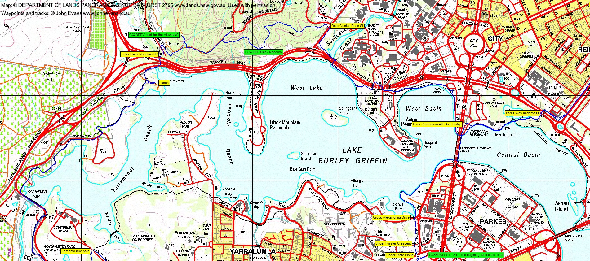
Crossing Alexandrina Drive, the Canberra Centenary Trail took us under Forster Crescent and under State Circle. Here, we strayed off route a few tens of metres to pick up geocache GC66R3J CCT – S1 – The begining (and end) of all. Thanks to Nathan’s eagle eyes, we retraced our steps to the rough CCT track (rather than the formed one up to Parliament House that I was going to take).
This little part of the CCT is a gem. Between State Circle and Capital Circle and within 200m of Parliament House, you could be out on a bush track miles from anywhere – except for the roar of the traffic going past.
We were delivered out the other end, crossed the looping fly-off from Adelaide Avenue to State Circle, walked under Adelaide Avenue and turned south-west up Melbourne Avenue. At the top, GC25BD5 Harry Houdini was found and logged.
Still on the CCT, we entered the Red Hill Nature Reserve and I puffed up the steep and staired track to the Tardis. Here I realised I’d missed a cache, so popped back down to log GC1MNKE Neighbourly Neighbours – Red Hill. Met cacher Kitty Katch on the way down, she and a friend training for the 25km Cbr100Challenge. Rejoining the others, I gave our meet at 10km joiner a call.
Over the crest of Red Hill Drive, we found the rock pile marking the track down the other side of the hill. Crossed Gowrie Drive and headed down the track to turn up to the reservoirs. Well known to me, but the party had strung out a bit. I dashed further off the route to log GC1FT36 Basil’s First Brush and so, of course, lost contact with 50% of the party. A phone call and several more, plus great common sense by the others, had us regrouped and with our fifth walker down on Kent St. Time for a quick morning tea.
More footpath as we tramped along Kent St, then across to join Dunrossil Drive and walk to the GG’s residence gates. Here one of our number left us and returned via the south side of the lake.
Hard on the feet bike path took us down under Lady Denman Drive (plenty of cyclists) and over Scrivener Dam. A lovely surprise of an echidna wandering along – hope it made it over the bike path or back up the hill and over Lady Denman Drive. A quick walk through the National Rock Garden, then to lunch on a picnic table near Acacia Inlet.
Back at it, we took the bike path under Glenloch Interchange, then uphill into the Black Mountain Nature Reserve. We all went for the detour up to GC2DRDV Just for the Views #9 (thank goodness, thanks for finding it Eric), then climbed the 100 vertical metres of the Lake View Trail. One only realises why it is named this when one lifts one’s head from the puff up, turns around and sees the great view down to the lake.
Again I was TIB,MIN and continued up to Black Mountain Drive before checking the GPSr and noting that we’d come too far. So back down the Lake View Track, looking for a turnoff. YOu can see from the map segment that I was about right for the turnoff, but no discernible track here. The green track is the official Cbr100Challenge 25km route and ours is the blue. I was too high after a while (it was a bit steep and slippery in walking shoes too), then too low. The latter didn’t matter, as we just had to log geocache GC409PE Black Meadow. From here, we did climb onto a foot track, followed it past another echidna and around the head of a gully, then down via braided trails onto Clunies Ross Street. (Perhaps I’ll go back and check this out thoroughly before bugging the event organisers.)

And a straight forward return to the cars via bike path and footpath, except for a little detour around the top of the Acton tunnel (is the work to do with the tunnel?) and the fact that you can’t buy sugar fizz at the pedlo hire or Mr Spokes bike hire places (the latter has only healthy water). A storm was coming in from the south and the rain edge chased us up Anzac Parade to only rain on our parade as we reached the cars.
Thanks for your company, everyone. And also your geocaching patience and nice comments about my poor route finding on the near-vertical side of Black Mountain.
Track Maps
Track overview
Track 1
Track 2

Track 3
Profile
Party
5 walkers – Eric D, Sally D, Jenny H, Nathan H, me.
Next Saturday’s Training
Saturday 9 January: Cbr100 training – Mt Tennent and Bushfold Flats – L/E. The usual Mt Tennent walk, plus a loop down the AAWT to Bushfold Flats and return up the Mt Tennent Fire Trail. For quick walkers please. Two start locations and times. Either Namadgi Visitors Centre at 8am or Lanyon Marketplace at 6am. Around 20km and 1100m climb, or 40km and 1250m climb. Maps: Williamsdale and Tuggeranong. Leader: John Evans 0417 436 877 john@johnevans.id.au . Transport: Drive yourself Namadgi Visitors Centre or Lanyon Marketplace. Please book.
Kittykatch
3 January , 2016 8:03 amHi John
Thanks again for your blog. My friend Cath and I will be walking the next section of the CBR100 25km route soon and will find your notes very helpful. Hopefully we will find the track on Black Mt too.
Cheers
Kath
Johnny Boy
3 January , 2016 8:44 amGreat to run into you Kath. When you find it let me know!