
‘Riding’ down Upper Left Hand Creek Fire Trail
Easter Friday arvo-Saturday 19-20 April: Clear Range (and beyond) mountain bike ride and stride – L&H. Good Friday arvo drive to the Mt Clear car park and ride 9km in to Horse Gully Hut. Camp overnight. Saturday ride a further 3km along the Naas Valley FT, then climb 300 vertical metres off-track to the Clear Range Fire Trail. Another 3km on fire trail and off-track gets us to our destination in NSW. Return the same way, including riding back to the parked vehicles. Around 35km and 500m climb. 4 remote geocaches. Map:Colinton. Leader: John Evans 0417 436 877 john@johnevans.id.au . Transport: You will need your own mountain bike and transport.
Further Information
A short one hour Good Friday service at Awaken Church Canberra South, so I was able to get away a bit earlier. This trip was to contribute greatly to my goal of logging all the traditional geocaches in Namadgi National Park and it was an “achieve all objectives or die”. We felt like we nearly did the latter.
Summary
Distance: 52.0km | Climb: 2030m | Time: 2 days | Grading: L/R,ptX; H(14)
Photographs
Photographs are available, where you can start a large sized slideshow.
Waypoint and Track Files
Download the gpx file for this trip (if your browser does not automatically download the file, it will open the gpx file in a new window and you can then save it). To use in Google Earth, do File, Open… and select Gps or All files as the File Type.
Track Notes
Day 1 – 19.7km and 630vm – ride, walk, push
It’s around 51km from my old folks home to the Naas Valley Fire Trail car park (very near the Mt Clear camping ground), The Boboyan Road is in not bad nick at the moment.
Bikes packed with panniers and a day pack on our backs, we were ready to roll at 11.50am. A 9.2km ride into Horse Gully Hut in 1hr 45mins. Somewhere along the way we found and logged the final GZ of GC1GRGB Colour in Canberra Too, although you won’t find the location or our detour to it on the map segments. We also called into Demandering Hut for the cache there for Marmaduke Rothschild.

Steeds hitched as we walk in to Demandering Hut
We couldn’t find it and I couldn’t remember where it was. A lot of remedial work going on at the hut.
Arriving at Horse Gully Hut, we found and logged GC831MZ Horse Hut. Located pretty close to business! Then lunch.
We had time to explore a few options. So we rode 3.3km in 20mins further north on the Naas Valley FT, dropped our bikes and walked over the rise to the dry Naas River. Geocache G target=”_blank”C2BZH5 Clear to Caloola: The Island took a bit of prizing from its cavity as it was firmly jammed in the back of its cavity. The front door log has been washed away.

Clambering around in a dry Naas River
From there we continued walking up the side of the SH1071 spur, then sidling towards the next cache on a cliff.

Approaching a cliff of interest 200 metres above the Naas Valley Fire Trail
Arriving, I went to pull out the printed spoiler picture … which was at HGH in one of my panniers. When will I ever learn? So that cost us 30mins of looking until Marmaduke Rothschild thankfully turned up the goods. Geocache GC2BZH7 Clear to Caloola: The Precipice logged and over 3 years of unlovedness released. Grand views from up here.
View from a cliff 200 metres above the Naas Valley Fire Trail
Now 3.50pm and the next cache (which most people hit from above) was only 740 crow meters away. We thought we’d try for it.
Delighted by the easy and quick going as we sidled the south side of the spur leading up to SH1214, then again delighted as the ‘forgotten valley’ came into view.

A ‘Forgotten Valley’ above the Naas Valley Fire Trail
30mins from cache to cache. A quick find and log of GC27GD4 Forgotten Valley, this time 2 years since the last log.
1.9km in 50 mins back down to the bikes and 3.1km in 30mins back to Horse Gully Hut.
We decided against a fire, water from the tank at the hut, had tea and were in bed by just after 7pm. The possums played on the roof of the tank till midnight, clanging about. A beautiful night sky – full Easter moon and cloudless display of stars. Mild.
Day 2 – 32.3km and 1400vm – ride, push, walk
Up before 6.30am, breakfast and away at 7.10am. A couple of options and, with hindsight, I chose the wrong one. We took our bikes and ended up pushing them more than riding. I’m pretty sure the riding advantage was nullified by the pushing.
From Horse Gully Hut, it was 2.7km of riding and pushing in 35mins to the bottom of Upper Left Hand Creek Fire Trail (at this junction the metal direction plates point the wrong way – the Upper Left Hand Creek Fire Trail is up). And up it is, 1.4km across the ground and rising 270 vertical meters. You’d have to be fit an strong to ride any of it. It took us 1 hour to reach the ACT-NSW border at the top.

Pushing up the Upper Left Hand Creek Fire Trail
Slippery gravel in places – on the really steep and slippery climbs it was brakes on to hold the bike, take 2 steps up, pull the bike up, repeat ….

1100m contour on the Upper Left Hand Creek Fire Trail
Exhausted by the time we reached the top.
The next 4hrs 25mins saw us progressing north along the crest of the Clear Range, again more pushing than riding.

Near SH1403 on the Clear Range Fire Trail
We were after the final GZ of GC1H4DA Forgotten Summit, which we found and logged somewhere during the round trip. The track maps have been doctored so as to not show the final location. So pleased when we made the find that I gleefully rang the cache owner and forgot to ring my dear wife.
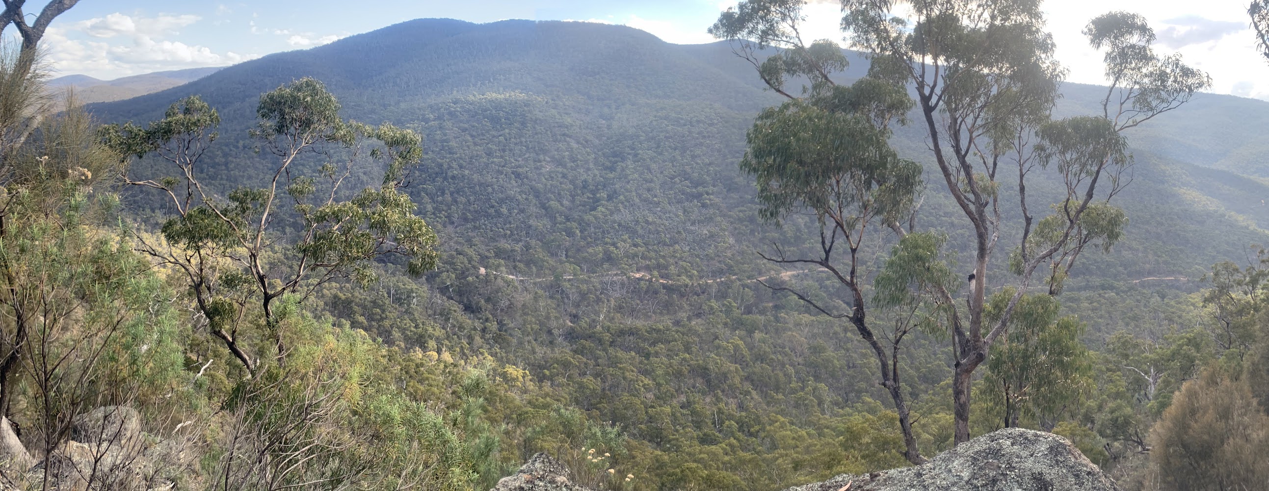
Some views down to the east of the Clear Range at times.

View east from the Clear Range FT near the top of Upper Left Hand Creek FT
Finally back at the top of Upper Left Hand Creek FT and we knew we couldn’t ride down it. But the down only took less than half the up, 25mins.
Then another 2.8km in 37mins back to Horse Gully Hut, pushing up that little hill in the middle – and on other occasions.
Lunch, pack up, grab some more water. 8.7km in 2hrs back to the car. A stop at John Brayshaws 2 Huts site and the remnant yards opposite.

Site of John Brayshaws 2 Huts beside Naas Valley Fire Trail
We downed some of a 3l bottle of Coke that was in the car.
Huge thanks to my good buddy Roger for coming on this trip! Never again (till next time) and did we discover that we’d Forgotten … something.
Track Maps

Track overview

Track 1

Track 2

Track 3

Track 4

Profile
Party
2 riders/pushers/walkers – Roger E (Marmaduke Rothschild), me (JohnnyBoyACT).