
Walkers at Mandawari Gate 6.38pm
Friday-Saturday 13-14 January 2023: Canberra Centenary Trail Sections 2+3 – Horse Park Drive to Hall (aka urban fringe Worn Boot Bash) * – L/E-M. Keen on walking at night, or want to try it? Let’s walk the northern section of the CCT, combining most of stage 2 with stage 3. Around 32km and 800vm, starting from Horse Park Drive and walking through Goorooyarroo, Muligans Flat and across to Hall. An opportunity to do only 13km to Forde, if you leave your car there when we set up the car shuttle. We’ll do a couple of Goorooyarroo hills before it gets dark. This trip could be regarded as an urban fringe Worn Boot Bash (Gooroo Hill, Oak Hill, One Tree Hill) and qualifies for RU⇧4it! Start at 6pm, finish around 3am or so – night walking is a bit slower. Car shuttle required. Bring plenty of tucker from the 5 food groups – salt, fat, sugar, chocolate, coke. A head torch is needed, preferably with a red light option so we don’t destroy our night vision. Sunset at 8:21, just see at 8:50.
Summary
From Garmin Connect – Distance: 31.54km | Climb: 806m | Time: 6:46 moving + 1:33 of stops = 8.19 | Grading: L/E-M; H(12).
Photographs Photographs are available here.
gpx File The gpx file is available here.
Track Notes
I was last in Goorooyarroo NR on 5 Dec 22, in Mulligans Flat NR on 8 Oct 22 and on the Forde to Hall section of the CCT on 20-21 Oct 17.
Always looking for something different, this trip had lots of objectives:
- night walking, which I always enjoy: tick
- to complete my penultimate section of the CCT: tick (only Kambah Pool to Tuggeranong to go, which is now reopened)
- a couple of hills for CBC’s current personal challenge RU⇧4it: tick
- (one of, as this trip was a bit whimpy) CBC’s 2023 annual Worn Boot Bash: tick.
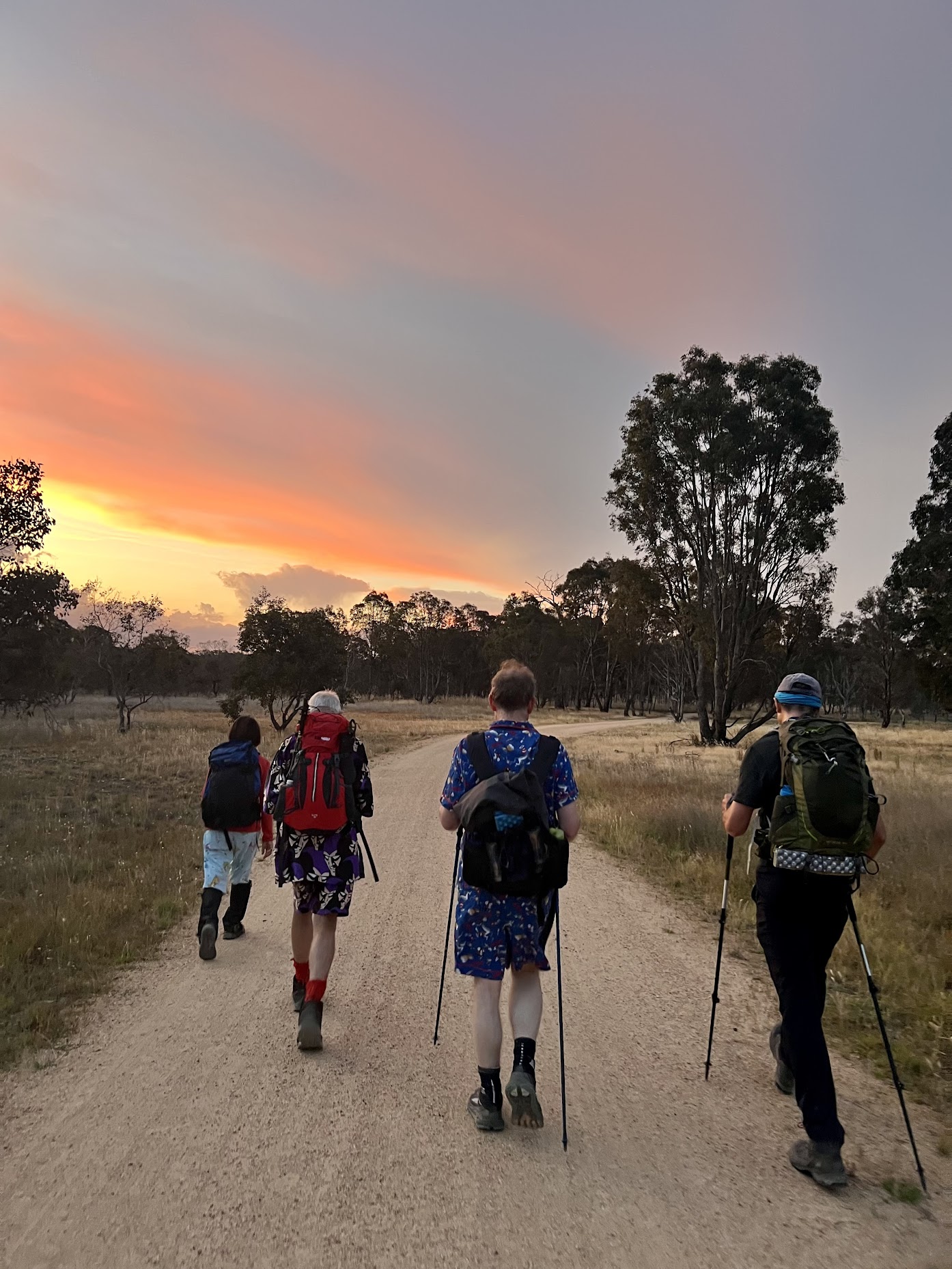
Of course, once participants were sucked in (I mean, had booked), they were informed that a night walk demands the wearing of pyjamas. Most complied – I suspect those who didn’t sleep naked!
We met in Hall and 3 cars whisked us to the start, the entrance to Goorooyarroo NR off Horse Park Drive nearest to the Federal Highway/HPD-Majura Parkway intersection.
A before photo (above). The winner of the ladies’ section was a tie – dinosaurs, butterflies/floral and a cheeky frilled number. Pos-pos the possum accompanied one. The outstanding gents’ winner was Dr Seuss. I couldn’t classify Richard, as he had Joanne’s nightie, so just let him power out front most of the trip.
It’s all very well to jolly along whilst the sun is up, but it’s quite different with head torches in the dark. So we had a couple of strategies:
- ‘buddy groups’ of 4, 4 and 3. “All your buddies here?” used at check point stops to save the leader having to count to 11
- a ‘tail end Charlie’. No one goes behind them.
Away at 6.40pm along the CCT through Goorooyarroo NR. The front runners learned the lesson to keep in touch with the leader at the turn off up to Gooroo Hill, as they had to U-turn back to the check point. Up the fire trail to the Banggu Gate.

Westering sun from the Banggu Gate 7.31pm (photo Kirsty G)
Through the gate then up through the long grass to Gooroo Hill. A circumnavigation of survey mark GN81 so we could claim the hill bag, followed by a brief visit to Gooroo Hill cairn.

Gooroo Hill cairn 7.41pm
The next leg was down on the outside of the predator-proof fence. Probably annoying my companions, I did several quick searches in the long grass for border markers. Only found F4.

Border marker F4 8.02pm
Back inside the fence through the Wiriya gate and back on the CCT.

Sun setting from the northern end of Goorooyarroo NR 8.13pm (photo Richard H)
A quick stop coming out of Goorooyarroo NR.

A quick stop about to enter Mulligans Flat NR 8.20pm (photo Kirsty G)
A few minutes later, out through the Bustard gate beside the Dungarvan site and into Mulligans Flat NR.

A flat Mulligans Flat from the Bustard Gate 8.26pm (photo Richard H)
Easy walking on the CCT here, flat but hard on the feet.
Walking the CCT through Mulligans Flat 8.34pm (photo Kirsty G)
A little later it was a delight to run into Teresa Z and friend. They were looking for a photography group, so did a U-turn and walked with us for a while till they met their group.
The toilets were useful at the Mulligans Flat shearing shed.

The sky at Mulligans Flat shearing shed 9.03pm (photo Richard H)
We pushed on out through the Woodland gate and so to the shelter shed at the Amy Ackman entrance to Mulligans Flat. Our first real break, apart from water stops. Tea was taken. I’d promised the previous Wednesday to check out the water here, but in the end didn’t drive around 80km return to do so. Saw a tap on a 2016 Google Street View though, so was reasonably confident. Yes, tap working and very welcome.
Off again at 9.37pm. Our next leg took us north along the concrete footpath to the North Mulligans Flat car park. The tail end Charlie was being rotated every 5km or so. It was head torches out for all starting this leg. The party management strategies came into their own and no one was lost/left behind.
The CCT took us up to the Dukes Road roundabout on Mulligans Flat Road, then climbing parallel to Dukes Road. Conversations waxed and waned, conversationalists changed from time to time. The track turned west. Views to city lights.

View from east of Oak Hill 10.36pm (photo Kirsty G)
The CCT then turned north and down to the Northern Campsite. Tank water (not used), toilet well patronised. A good supper break.
Left at 11.26pm. The CCT describes an arc, with many twists and turns, on its way to the bottom of One Tree Hill. It passes very close to the northern-most point of the ACT, but it’s very near a house in NSW, so we did not visit.

City lights from near One Tree Hill 1.30am (photo Kirsty G)
Reached the bottom of One Tree Hill around 1.40am.

Lights of Taylor and the night sky from bottom of One Tree Hill climb from CCT 1.40am (photo Kirsty G)
It was quite windy and cool as we climbed, so only a short stay at the top. A hill/trig bag.

Encroaching Taylor lights from One Tree Hill 1.48am (photo Richard H)
We returned down the way we came, the long grass and animal holes in the dark precluding the direct descent.
All downhill now and we arrived at the Hall reservoirs at 2.52am.
Last noise (not last drinks) called here, as our cars were parked opposite houses in Hoskins Street. Finished at 5.59am, just one minute before the estimated time.
I’m sure we all enjoyed this little experience, despite possibly sore feet and upset circadian rhythms.
Car shuttle drivers taken back to the start. All others home to bed. A great trip.
Track Map
Here’s where we went. On Hall 1:25000 map from NSW LPI SIX e-topo (converted to tif for use in OziExplorer).

Track Night walk – Horse Park Drive to Hall
The AllTrails map is here, where you can pan and zoom.
Party
11 walkers – Kirsty G, Laili H, Richard H, Stephen J, Ming L, Daniel P, Michael R, Tilly T, Sandra T, Ian W, me.
Johnny Boy’s Walkabout Blog FaceBook Page
I’ve started up a FaceBook page. Each trip report posts to it. So it’s another way to get some info to get out and breathe a bit of fresh air. Why not pop over and Follow the page, or give a post a Like.
Terrylea
14 January , 2023 4:54 pmWhat a riot. So sorry to have missed this wonderful night walk.
Am wondering if I can get the phone number for the cute fella with the red socks and the phantom jamies. He looks like fun!
Seriously, what a super idea, John.
Definitely think an article should go in the Quarterly newsletter about this, replete with pictures, an absolute hoot. 🙂
Johnny Boy
14 January , 2023 5:08 pmA great Canberra Bushwalking Club trip, TL. Always looking for something different. The Phantom pjs are at 0412 345 678.