The south-east slope of Mt Majura

Monday 12 October: Early Bird Walk – Mount Majura – S/E. Starting at 7 am, we will go for a walk for 1 to 2 hours mainly on urban bushland tracks to the summit of Mount Majura. Afterwards there will be an opportunity to go for breakfast. Map: http://www.tams.act.gov.au/__data/assets/pdf_file/0005/390578/cnpmapmajura.pdf Leader: Lorraine T. Meet: at the carpark on Antill Street in Hackett (UBD 50 E1) No need to book.
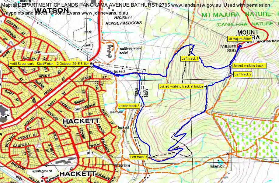
2 of us met at the Antill St car park.
Summary
Distance: 6.1km | Climb: 280m | Time: 7.00-8.45am (1hr 45mins) | Grading: S/E-M; E(7)
Photographs
Photographs are available, where you can start a large sized slideshow.
Waypoint and Track File
Download the .gpx file. (Right click, Save Link As…, Save – if you want to use it.)
To use in Google Earth, do File, Open… and select Gps or All files as the File Type.
Track Notes
It is said that ‘absence makes the heart grow fonder’ and this is true. But my loved one tells me that my enforced layoff from walking has also made me like a bear with a sore head. However, 32 years of spring cleaning in a month has been completed and our home is on the market. Yours for the right price. So back to walking!
We are so fortunate in Canberra to have a surfeit of inter-urban and urban fringe walking opportunities. The Canberra Nature Park, a collection of 33 areas within our city, provides many of these. Today we walked in the Mt Majura Nature Reserve.
It was a combination of tracks, footpads and off-track, including a careful descent of the rocky gully that slices the south-west flank of the hill, down to the bridge on the track. The gully was filled with daisies in flower.
A coffee at the newly opened and very nice The Knox made in Watson. Congratulations Dan C and staff.
Thanks Lorraine. A lovely and gentle reintroduction to walking.
Track Map
Track
Party
2 walkers – Lorraine T (leader), me.