TikvaNZ makes the significant find (that’s water immediately above his head)

Saturday 10 December: Ginini Falls with geocacher Cankid – M/R. A trip to log GC2G23C GININI FALLS (if we can get there) – and to admire the views of course. A couple of others on the Mt Franklin Walk. Around 11km and 780m climb out. Fit and experienced walkers welcome to hold my hand. Map: Tidbinbilla. Leader: John Evans 0417 436 877 john@johnevans.id.au . Transport: ∼$16 per person.
GC6JAYP Franklin Fireplace, GC6BPP1 Yowie Sighting and GC6BPPJ Yowie Chase
8 of us met.
Further Information
Last times here were 1 Mar 06 and 17 Apr 07. I am a lot older and the bush requires more bashing now. Would have taken another couple of hours, except we had Wayne the bulldozer making the going most of the day.
Summary
Distance: 10.7km | Climb: 685m | Time: 8.00am – 4.10pm (8hrs 10mins), including 50 mins of breaks | Grading: M/R; M(11+++)
Photographs
Photographs are available, where you can start a large sized slideshow.
Waypoint and Track Files
Download the .gpx file. (Right click, Save Link As…, Save – if you want to use it.)
To use in Google Earth, do File, Open… and select Gps or All files as the File Type.
Track Notes
We met at Cooleman Court and drove to Piccadilly Circus and south down the Mt Franklin Rd to the Mt Franklin car park.
A stroll up the Mt Franklin Walk, quickly picking up GC6JAYP Franklin Fireplace, GC6BPP1 Yowie Sighting and GC6BPPJ Yowie Chase. Then on up to the Mt Franklin trig.
I’d spied an old fire trail alignment on Google Earth that headed off from here to the NE, then heading down generally to the east (Nick had it on his SIX map segment too). We began to follow it; one of the visitors was a bit crook, so 2 of the party left us here and spent the day around the top of Mt Franklin. Planned waypoints 3-6 provided a bit of guidance, with the track alignment gradually deteriorating and visible only by the gap in the trees populated by younger growth. It petered out just after waypoint 6.
Waypoints 7-9 were again planned points, just to keep us going down and up the appropriate spurs. We actually settled into quite a good routine for a lot of the trip, with Wayne the bulldozer out front and me on the GPSr following. He has a marvellous sense of direction and a correcting veer was rarely needed. It was reasonably hard to read the lie of the land in all the bush and the spurs were mostly broad.
The leg from the end of the track alignment to the one open spot on the whole trip, marked Cairns and granite slab views, saw the immediate closing in of the vegetation and we spent the rest of the day severely bushbashing. The distance was around 660m and it took 30mins going in and 55mins coming out. During our break coming out some secret geocaching rituals were practised.
Somewhere during the next leg from the cairns to morning tea near waypoint 8, the bush snatched my camera. So the only photos I have are a couple taken with my GPSr and, as usual, I seem to get the carabiner and carry case obscuring half the pic. It was tough going, the 870m across the ground taking 52mins going in and 1hr coming out.
One relief from the constant bushbashing was the presence of fallen trees which provided, when they had fallen in our desired direction, a clear highway. One run of several linked trunks took us 50m and another had us balancing at least 2m above the ground.
The final leg from morning tea to the Ginini Falls cache was 700m and took 50mins going in and 1hr coming out. As we got closer to the day’s main goal, spirits rose among the geocachers. TikvaNZ, who had special goals to achieve today, got the smell of the cache and led the charge down the steep (check out the profile pic!) final approach. It was a mite hairy, one false step would have seen you at the bottom of the 140m falls. The log book of GC2G23C GININI FALLS was gleefully signed by all and the huge drop and sliver of water admired.
Roger kindly led the slow ascent and bashbash back to lunch.
Then the slow slog out. No camera found. A call to my friendly AAMI insurers once home and a replacement is in train, but today’s pics lost.
A couple more caches on the way back to Mt Franklin and we rejoined our companions at the Shelter.
This was a big day. One of the party was 50 years younger than me. I was exhausted. The numbers give it a BBC grading of M(11), but it is a lot (like +++) harder than that. I can confidently say that I’ll never be back there … unless there is another opportunity 🙂 .
Huge thanks to the party, great result.
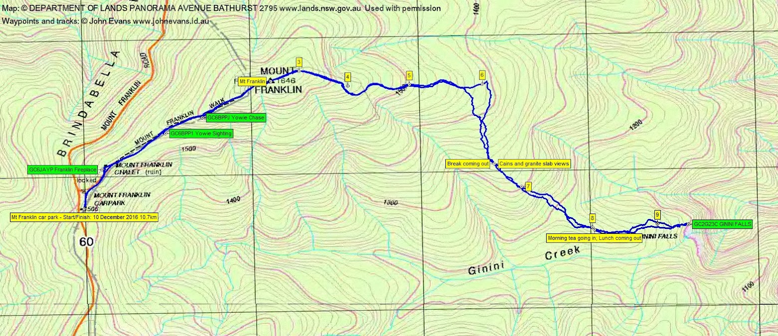
Track Map
Track
Profile

Party
8 walkers – Nick B (ANUMC), Wayne B (Fox in Jox), Max C (ZQX), Hugh C (Cankid), Roger E (Marmaduke Rothschild), Martin E (TikvaNZ), Taya F (ANUMC), me (JohnnyBoyACT).