
Namadgi hills from the Yerrabi Track granite slabs
Saturday 10 May 2025: Four Short Walks from the Boboyan Road * – M/M. These walks are designed to introduce newer members to the central area of Namadgi National Park. Of course, anyone is welcome to come on the hikes. Drive down the Boboyan Road for:
1 Stop at the steel lookout above Hospital Creek for signage to explain the Namadgi hills in view to the west.
2 Shannahans Mountain Walking Track is a 3km loop providing views to the east and the Clear Range.
3 The Yerrabi Track of 4km showcases different geological features in Namadgi National Park. It ends at some remarkable granite slabs with views to the hills in the heart of Namadgi National Park.
4 A 6km round trip from the Rendezvous Creek carpark crosses Rendezvous Creek via a bridge and traverses open grasslands, woodlands and fire trails in the Gudgenby area. It includes Gudgenby Homestead and the Ready-cut Cottage.
A total of around 13km and 400vm.
Summary
From Garmin Connect (recorded on Epix Gen 2)
Walk 1: Maybe 10m.
Walk 2: Distance: 3.18km | Climb: 120vm | Time: 0:55 moving + 0:05 of stops = 1:00
Walk 3: Distance: 3.58km | Climb: 240vm | Time: 1:08 moving + 0:38 of stops = 1:46
Walk 4: Distance: 6.85km | Climb: 175vm | Time: 1:44 moving + 0:54 of stops = 2:38
Total: Distance: 13.61km | Climb: 535vm.
Photographs
View photographs here.
gpx file
Download the gpx file here.
Track Maps
Here’s where we went on W1 and W4:

Track Four Short Walks from Boboyan Road W1 and W4
Here’s where we went on W2 and W3:

Track Four Short Walks from Boboyan Road W2 and W3
Trip Report
I could get used to these easy rambles. Another one of 4 parts on a glorious Autumn day.
Walk 1 – Hospital Hill lookout
We stopped at the lookout, about one kilometre past the end of the sealed road. Wonderful views to and signage about the high hills at the heart of Namadgi National Park.

View from Hospital Hill Lookout
Walk 2 – Shanahans Mountain Walking Track
Yonks since I did the Shanahans Mountain Walking Track, last on 19 Jul 14. Then I probably gave it a 2 star rating.

Walking towards the views on Shanahans Mountain Walking Track
But I was pleasantly surprised today, once we reached the top of the ‘mountain’ to take in the views.

View to Clear Range and Tinderry Range from Shanahans Mountain Walking Track
I upgraded my rating to 3.5 stars 😏. Even the exit was pleasant.

Shanahans Mountain Walking Track at SH1423
Walk 3 – Yerrabi Track
Always a nice walk, passing through many different vegetation zones. I was last here on 9 Mar 22. Brochures in the box at the start of the walk. Great signage at Little Dry Creek.

Signage on the Yerrabi Track
We climbed to the trig (me puffing).
Boboyan trig
This is another slightly misnamed Mountain, Mt Boboyan, although it’s a bit of a haul if you come up through the scrub from the Old Boboyan Road (down below us today). The similarly named Boboyan Hill is around 7km as the crow flies to the SW.
As the track descends through the granite there is the marking of the construction, done by NPA ACT.

Yerrabi Track constructed by NPA ACT 1987
Not being able to decipher the third digit of the date, a quick enquiry to Mike B, the Outings Convenor of NPA ACT, gave me the good oil. Check out page 6 of the publicly available June 1987 NPA Bulletin.
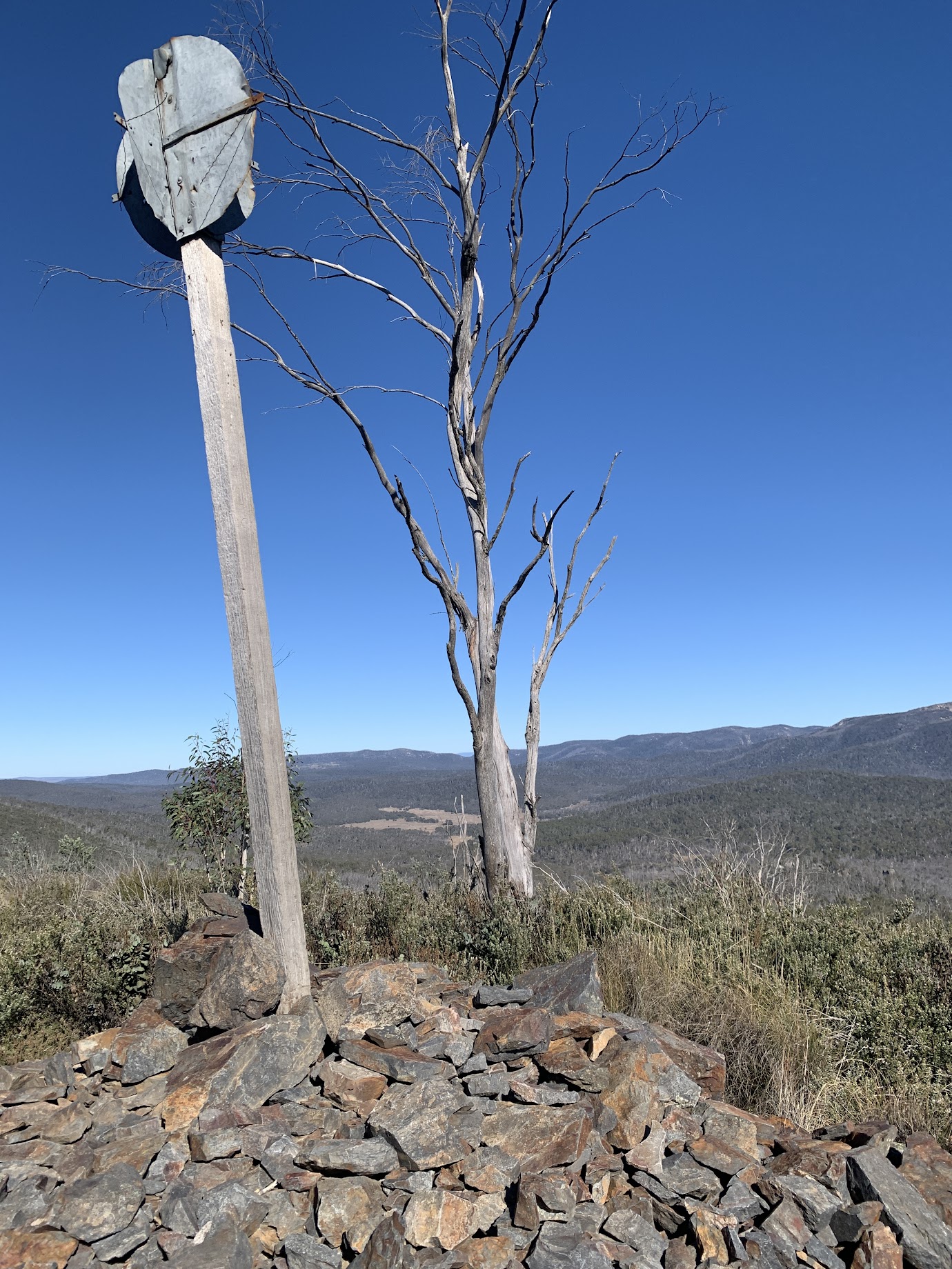
Down on the granite slabs there’s great signage.

Signage at the Yerrabi Track view slabs
And incredible views!
Namadgi hills from the Yerrabi Track granite slabs
Just the spot for smoko.
PeakFinder is a great app. Around $10 one-off purchase. Point your phone at the view and it will name the hills for you.

PeakFinder shot
It works world-wide, based on OSM (Open Street Map) data. The data is crowd sourced, so there can be some irregularities. In the above, ‘Sentinel Rock’ is actually Sentry Box Rock. I was interested as a good mate will be up in that area at the end of the month and this old codger will stroll into Lutons Crutching Shed to camp to meet them as they come down. You’re welcome to book on my chilly camp on 1-2 June.
Walk 4 – Rendezvous Creek Walking Track and Gudgenby Grasslands
We drove slowly back onto the sealed road (the Boboyan Road dirt is very corrugated and therefore slow atm) to the Rendezvous Creek carpark.
I was last in this area on 28 Sep 24.
Over the bridge on the walk, the creek sparkled in the sun.

Rendezvous Creek just after crossing bridge 1
Out on the dry grasslands we crossed the Rendezvous Creek old vehicle track. Great views up the valley and to the Mavis Ridge. We headed to the SODAR (Sonic Detection And Ranging) installation, then the spaceship-like structure (SES comms and weather station) nearby.
The ‘Front Paddock Shelter’, an aboriginal rock shelter, was a good lunch spot.

‘Front paddock’ aboriginal shelter
A lot of my knowledge of aboriginal and European sites in what is now Namadgi National Park comes from J H Winston-Gregson’s 1978 MA thesis. He scouted around the area, documenting both aboriginal and white fella sites. Over the years I’ve visited most of them. The ‘Front Paddock Shelter’ is one such site.
After lunch we walked down to join the Middle Creek Fire Trail. I fulfilled a bucket list dream by going up and over a cameo little knoll of granite, SH1003.

SH1003 above Gudgenby Homestead
Over the other side is Gudgenby Homestead.

Gudgenby Homestead
What I know about it is here.
I had a word with Isobell C. She and two other members of the Gudgenby Bush Regeneration Group were pulling out briar roses along the Gudgenby River. Folk like these caring for the land always give me the guilts – all I do is walk on country. Hats off to them!
We crossed the Gudgenby Footbridge and did a lap of the Readycut Cottage.
Walking out the road, we ran into two large groups of Scots College Sydney boys and teachers doing a 4-day hike.
Some of us had a look under the Rendezvous Creek culvert. Just to show that you can teach an old dog new tricks, my companions found a better way back to the nearby vehicles.

Crossing Rendezvous Creek
Most of the party had not been to these locations, so I trust the day was enjoyed.
The AllTrails map is here, where you can pan and zoom.
Party
8 walkers – Matthew F, John G, Cathy K, Tarn L, Jane M, Phillip S, Catherine W, me.