… with guest blogger Terrylea R

SE Mavis Ridge, Yankee Hats North and South, Mt Gudgenby, Mt Mouat, Burbidge Spur, Mt Burbidge, Mt Namadgi, Mt Mavis and the NW Mavis Ridge
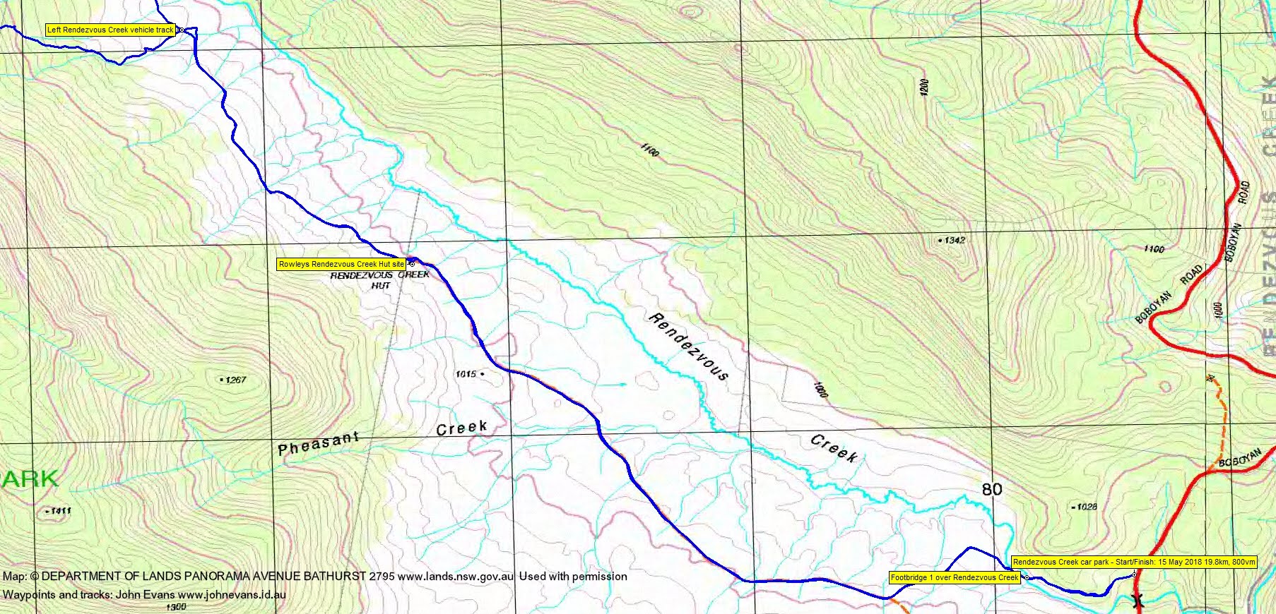
Tuesday 15 May: Mt ‘Herlt’, Namadgi National Park L/R,X. Mount Herlt is a 1600 metre high point (and Percy) at grid reference 739479. It is difficult to reach because of the thick regrowth resulting from the 2003 bushfires. On this walk, we’ll start on the Boboyan Road and follow the vehicle track adjacent to Rendezvous Creek for 5 km. We’ll then head off-track for most of the day and visit Mt Herlt and some other big granite outcrops in the vicinity, if the scrub allows. Minimum distance 18 km with 800 metres ascent. Map: Rendezvous Creek. Leader: Ian W. Transport: 107km return. Limit: 8.
Further Information
I was last on Mt Herlt on 28 Jun 06, 14 Aug 07 and 24 Nov 09.
Mt Herlt – GR739479 (MGA94), Spot Height 1612 on the 1st edition Rendezvous Creek 8626-1S 1:25000 map and the feature above the 1600m contour on the 2nd edition map. Mt Herlt was named after Tony Herlt, a tiger walker in the 1970s who led a lot of day trips in Namadgi. It is probably best known for the huge granite rock face on its northern side. Alas Tony “retired” from bushwalking when he became a family man but if my memory is correct my naming of the mountain after him did entice him back to do this walk. (Information provided by Jeff B, the ‘horse’s mouth’ who named Mt Herlt.)
Summary
Distance: 19.8km | Climb: 800m | Time: 7.40am – 4.20pm (8hrs 40mins), including 55 mins of breaks | Grading: L/R; H(14)
Photographs
Photographs are available, where you can start a large sized slideshow.
Video
Waypoint and Track Files
Download the gpx file for this trip (if your browser does not automatically download the file, it will open the gpx file in a new window and you can then save it). To use in Google Earth, do File, Open… and select Gps or All files as the File Type.
Track Notes
Terrylea writes …
When it’s -1ºC outside and a group of ten usually rational and intelligent Canberra adults are standing around excitedly in the carpark of Lanyon Marketplace at 6:50 am on a Tuesday morning you know something special is about to happen. It was. It was Tuesday and on Tuesdays Ian W leads rational and intelligent adults astray – always to the most interesting places and today was no exception.
We were headed for Mt Herlt. ‘Where is that?’ you might ask, as I did when I tried to find it on the Rendezvous Creek 1:25000 map. I couldn’t see any mention of Mt Herlt. Not to be daunted I went to my trusty Backcountry Navigator app on my smartphone thinking I’d find it there. Nope, no luck there either. I like to be prepared and have a rough idea of where I’m going. I like to download the relevant map areas and use them offline when there’s no phone signals. Well I’d just have to see, I decided, as I jumped in the car with 4 others and we commenced the long drive to the Rendezvous Creek Car Park along the Boboyan Road.
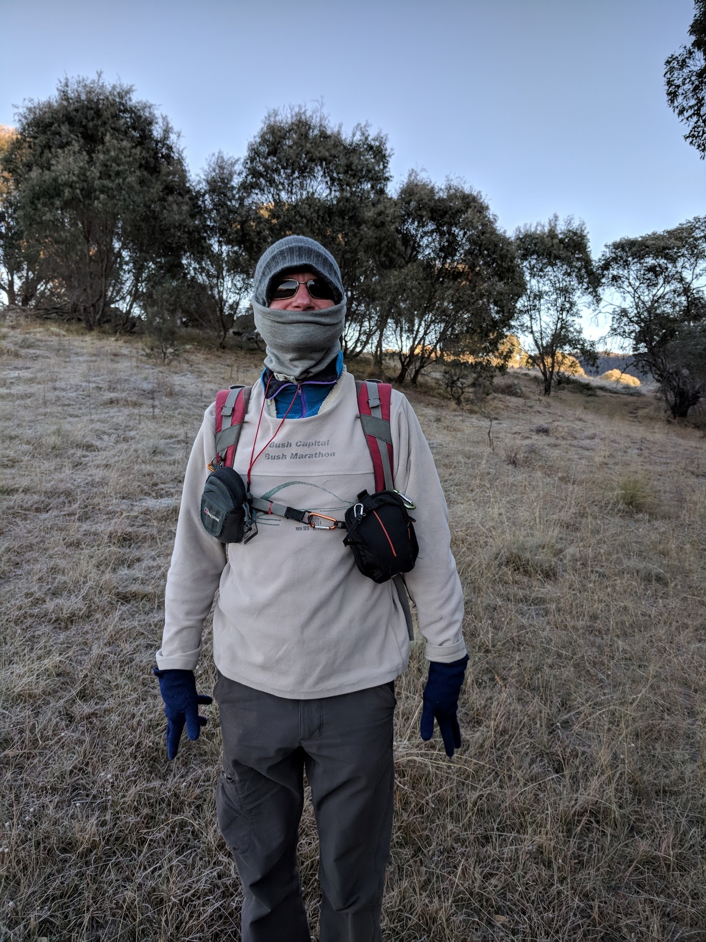
At 8:45 am we were all geared up sporting the usual bushwalking fashion accessories – gaiters, glasses and gloves as we started walking on the old vehicle track adjacent to Rendezvous Creek where our leader set off at a cracking pace to keep warm:

Frosty going over the Rendezvous Creek footbridge
With his balaclava and face warmer in this season’s Autumn-Winter fashion colour of Duck-Egg Blue, Ian was ‘on trend’, unlike a couple of other members of the party whose idea of fashion was to wear hiking pants with duct tape holding them together! (No name used here to protect the innocent fashion victim concerned but ‘he’ knows who he is):
The open grassland still sparkled with frost and ice as we kicked it up a notch heartened by the sight of Mavis Ridge to our left and Mt Herlt, our goal, in sight. The sun had started to shine and we knew were in for a treat:

Walking the Rendezvous Creek vehicle track
After 30 minutes we still hadn’t warmed up though and, instead of the usual stripping off of the top layer, we stayed rugged up for another half an hour or so – except for Bruce, who decided the fastest way to warm up was to throw in a couple of quick push-ups along the way.
We left the old vehicle track approximately a kilometre or so north west of Pheasant Creek and were pleasantly surprised at how easy going it was in the low open woodland cover which dominates much of the Namadgi National Park.
Morning tea was called at ten, after which we were all feeling well-nourished, so Ian again started us moving and we commenced the climb up towards Mt Herlt with enthusiasm. The going was slower this time as we wrestled our way through Common Shaggy Pea, Tea-tree, Mountain Pepper and Wattle and carefully maneuvered our boots over fallen timber:

Some open granite slabs at 1540m contour SE of Mt Herlt
Snow, Mountain and Ribbon gums started to appear on the higher slopes to remind us that, even though we’d started to warm up, this was all still ‘cool area’ mountain forest and we shouldn’t forget that it snowed up here less than a week ago:

An iced pool at 11am, SE of Mt Herlt
By noon however we’d arrived at the top, after much huffing and puffing (and Cassinia-induced coughing), to be greeted with the most spectacular granite monoliths. Well it was a walk led by Ian, the ‘granite-hunter’, after all!
We tucked into our well-earned lunch in the sun all the while admiring the western skyline as it was now a beautifully clear day with just a few scattered wisps of clouds and airplane contrails above us. There was a bit of bemused laughter when one of us noticed that one of the planes had done an about turn and we all checked that none of us had inadvertently sat on our PLB! There in the distance was Mount Kelly, Mount Mouat, Mount Burbidge, that old favourite Gudgenby and, of course, Mount Namadgi:

Mt Namadgi and Mt Mavis from the ladies’ lounge at lunch
Half an hour later though Ian had us all up and moving again knowing full well that there was a long and difficult climb ahead of us. But the fun was still to come! Those granite boulders were beckoning and within minutes there we were scrambling up and over, around and through, betwixt and between them. We squeezed ourselves through narrow gaps passing our packs ahead of us. We slid down their sides onto the soft ferns below. We jumped and we leapfrogged from one boulder to another watching carefully for the odd patch of ice which remained from the overnight freezing temperatures. Those same ten rational and intelligent adults that had met in the car park a few hours earlier had suddenly been transported back in time to the carefree days of childhood. It was like a jungle gym for grown-ups!

A sheltered fernery in the granite just after lunch
But all good things come to an end – even for grown-ups and so with smiles still on our faces (and bruises on our limbs) back we went through the vegetation, this time in a clockwise direction giving us grand views of Nursery Swamp, Nursery Hill and the Rendezvous Creek valley eventually picking up our trail again a couple of hours later:

Views over Rendezvous Creek to Nursery Swamp and Nursery Hill from our descent at 1530m
A quick pit stop for afternoon tea then it was off again to slog along the five or so kilometres of vehicle trail back to the cars, but not before this writer realized she’d lost her sunglasses 50 or so metres back. Luckily for me it was gentlemen to the rescue as both Philip G and Jonathon M reversed gear and helped to scour through tussocks with those pesky sunglasses eventually turning up. Thank you Philip G for your eagle eyes!
I always find that there’s something about that homestretch which makes you yearn for the car, for the chance to get those boots off (especially when the homestretch is five kilometres of hard trail), to sit and relax while someone else does the driving, perhaps even to think about that nice steaming hot cup of tea that awaits. But the rewards come to those who are patient – to those who walk at the back of the pack – even on the homestretch. After some lamenting about the lack of birdlife on our walk Philip G and I spotted two magnificent wedge-tailed eagles perched proudly atop a dead gumtree only about 100 metres away across the open grassland. Then a couple of flame robins sailed past and nestled gently into some smaller shrubs. The ‘twitchers’ amongst us were satisfied!

Eagles | photo Philip Gatenby
We piled back into our cars at about 3:45 pm and after the usual game of dodge the errant wallaby, or kangaroo with a death wish, we were back at Lanyon Marketplace around 5 pm, just in time to join the peak hour traffic.
Another day in Namadgi with the consummate Ian W delivering, yet again, an outstanding walk.
Track Maps


Track 2
Profile

Profile
Party
10 walkers – Monika B, Bruce, Jan G, Philip G, Meredith H, Jonathan M, Terrylea R, VT, Ian W (leader), me.