
Ranger Adam talking about dingoes at the bench and table
Saturday 28 September 2024: NNP 40th anniversary walk – Rendezvous Creek and Gudgenby Grasslands Hike * – S/E-M. CBC was invited by Namadgi National Park Management to facilitate walks for the public to celebrate the 40th anniversary of the Park. This walk covers the southern part of Rendezvous Creek and the northern area of the Gudgenby Grasslands.
Summary
From Garmin Connect (recorded on MAP66i) – Distance: 8.04km | Climb: 120vm | Time: 2:14 moving + 1:53 of stops = 4:07 | Grading: S/E-M; E(6).
Photographs
View photographs here.
gpx file
Download the gpx file here.
Track Map
Here’s where we went.
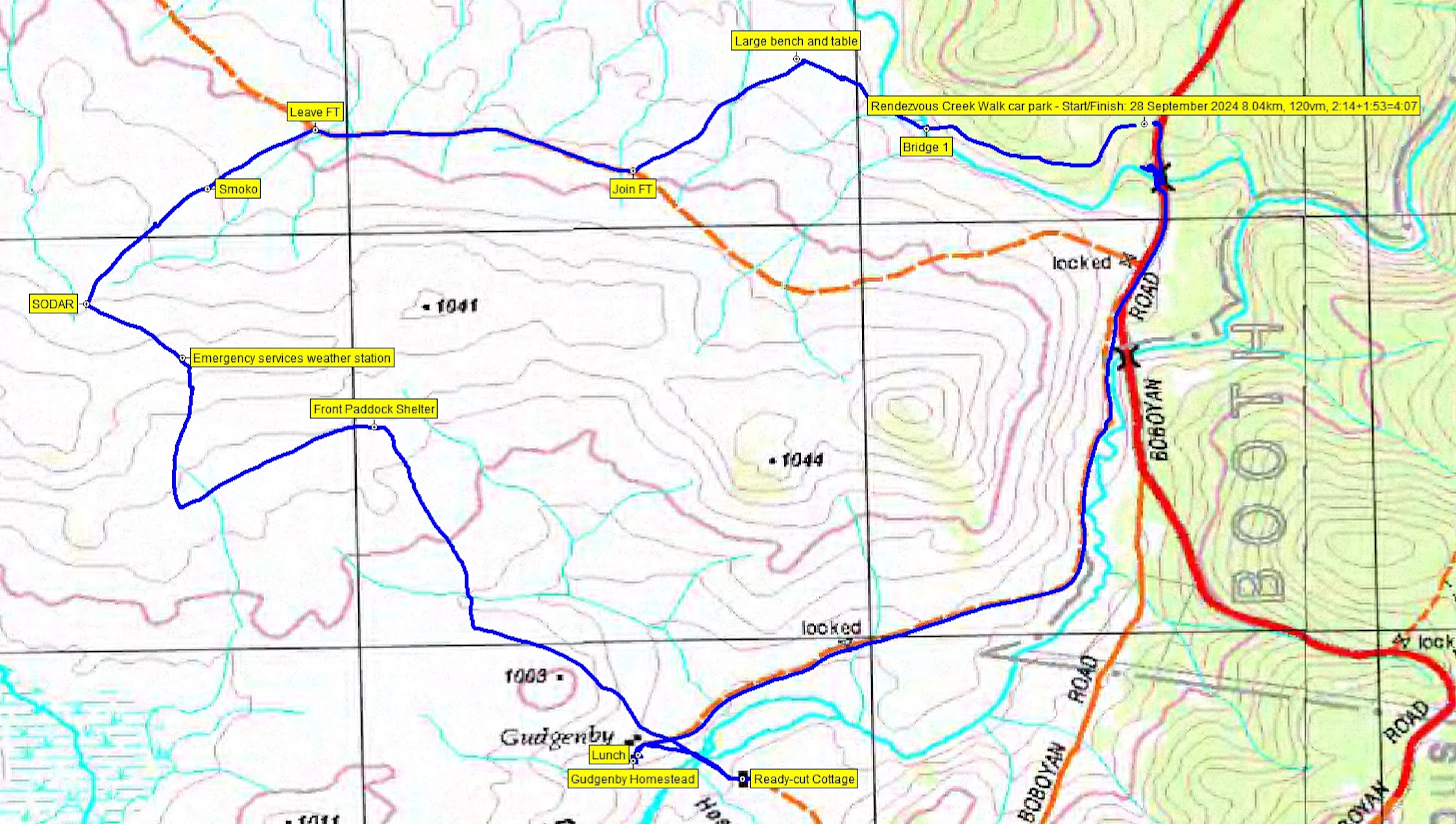
Track NNP 40 Rendezvous Creek and Gudgenby Grasslands
Trip Report
I last did this little trip on 31 Jul 24.
We met at the NVC and were joined by Ranger Adam. After introductions we motored in convoy 27km south to the Rendezvous Creek car park. Pre-walk briefing, shook out and were away at 9.30am.

Leaving the Rendezvous Creek car park
Slow walking to appreciate the creek flowing below and to stop every now and again for Ranger Adam to share information.

Ranger Adam gives us the good oil
Rendezvous Creek was flowing clean and strong.

On the bridge over Rendezvous Creek
After our stop and the bush table and bench, we struck out SW to the Rendezvous Creek fire trail. Beautiful weather and great views up the valley and its ridges on either side.
Several hundred metres along the fire trail we left it to head SW and gently up towards the SODAR. A grass spot was perfect for a lazy smoko.
Adam shared information with us on a range of issues, including feral animal control.

Pig carcass
We stopped at the SODAR and weather station/comms infrastructure on the low crest of the divide between the north and south parts of the walk. Super good from Adam to hear the story behind the fenced off areas (to eventually create habitat links) and areas of spread timber (from the Curtin timber pile!).
Instead of going directly to our next location, we went downhill to a lone fenced tree. Incredible to hear of the effort made to rehabilitate it.
Back slightly up to the Front Paddock Shelter. Then down to join the Middle Creek fire trail (not shown on the map above). Followed it to Gudgenby Homestead, then across the bridge to walk around Teady-cut Cottage (closed for use at the moment).
Then back to Gudgenby Homestead where a real treat was experienced.

Walking up to Gudgenby Homestead
Ranger Adam opened up. Toilets were available and we were permitted to have a look around.

Looking out the dormer windows of Gudgenby Homestead
Lovely timber flooring.

One of the rooms in Gudgenby Homestead
As we sat outside for lunch there was heaven for some and hell for others – wi-fi connection via SkyLink 😊.
A parting photo.

Ready-cut Cottage from the entrance to Gudgenby Homestead
And so back via the entry road to join Bobeyan Rd.

Looking down the Gudgenby River to the Bobeyan Rd
A visit to a special site.
Trust everyone enjoyed it. Huge thanks to Adam for sharing so much information that helps us understand the landscape in which me walk.
Party
12 walkers including Ranger Adam, 4 leader-helpers Jenny A, David D, Sal O, me and 7 members of the public.
Johnny Boy’s Walkabout Blog FaceBook Page
I’ve started up a FaceBook page. Each trip report posts to it. It’s another way to get some info to get out and breathe a bit of fresh air. Why not pop over and Follow the page, or give a post a Like.
Additional Trip Reports
As I age, I’m doing a few more simple hikes. I don’t always produce a full trip report. If you’re interested, you can find details of them on the Completed Walks tab. There you can access the trip’s map segment, download a gpx file, see the distance, climb and grading, and link through to the photo album. Additional metrics are available by looking at the start waypoint on the map segment – moving time, stopped time, total time.