
Walkers at Lower Cotter Catchment Lookout (photo Mick S)
Saturday 12 July 2025: Cotter sights and sites * L/E. Check out the easy track walks around Cotter – Cotter cave, Cotter Dam Discovery Trail for spillway views and informative signage, Honyong-Cotter Walking Track for dam views, Grass Tree Lookout Track for … grass trees. Lunch at Cotter Bend (toilets). After munchies, drive up Brindabella Road to do burnouts park. Walk to Mt McDonald, including Cotter Dam views. Around 16km and 565vm.
Summary
From Garmin Connect (recorded on Epix Gen 2) – Distance: 14.5km | Climb: 480vm | Time: 6 hours | Grading: M/E; M(8).
Photographs
View photographs here.
gpx file
Download the gpx file here.
Track Maps
Here’s where we went:

Track Cotter Sights and Sites Walks 1-4

Track Cotter Sights and Sites Walks 5-6
Trip Report
Huge thanks to Steve G, Canberra’s best expert on things ACTMAPI, historical things, trigs, etc. He pointed out to me that I have McDonald trig and McDonald ecce incorrectly interchanged. With Steve’s advice and 20/20 hindsight, the topo map markings make perfect sense.
I was last in this area on 21 Jun 25, having a little look-see.
The day divided nicely into two parts. In the morning we did 4 little walks and in the afternoon 2.
Walk 1 – Cotter Cave
We started from the Cotter Bend carpark and crossed the Cotter River via a footbridge. Turning south on a little footpad, this took us to a fire trail paralleling the true left side of Paddys River. Strangely, this fire trail is open to 4WD vehicles which noisily climb up the Bullen Range Fire Trail and so along the crest of the Range. Steps leave on the right and past signage.
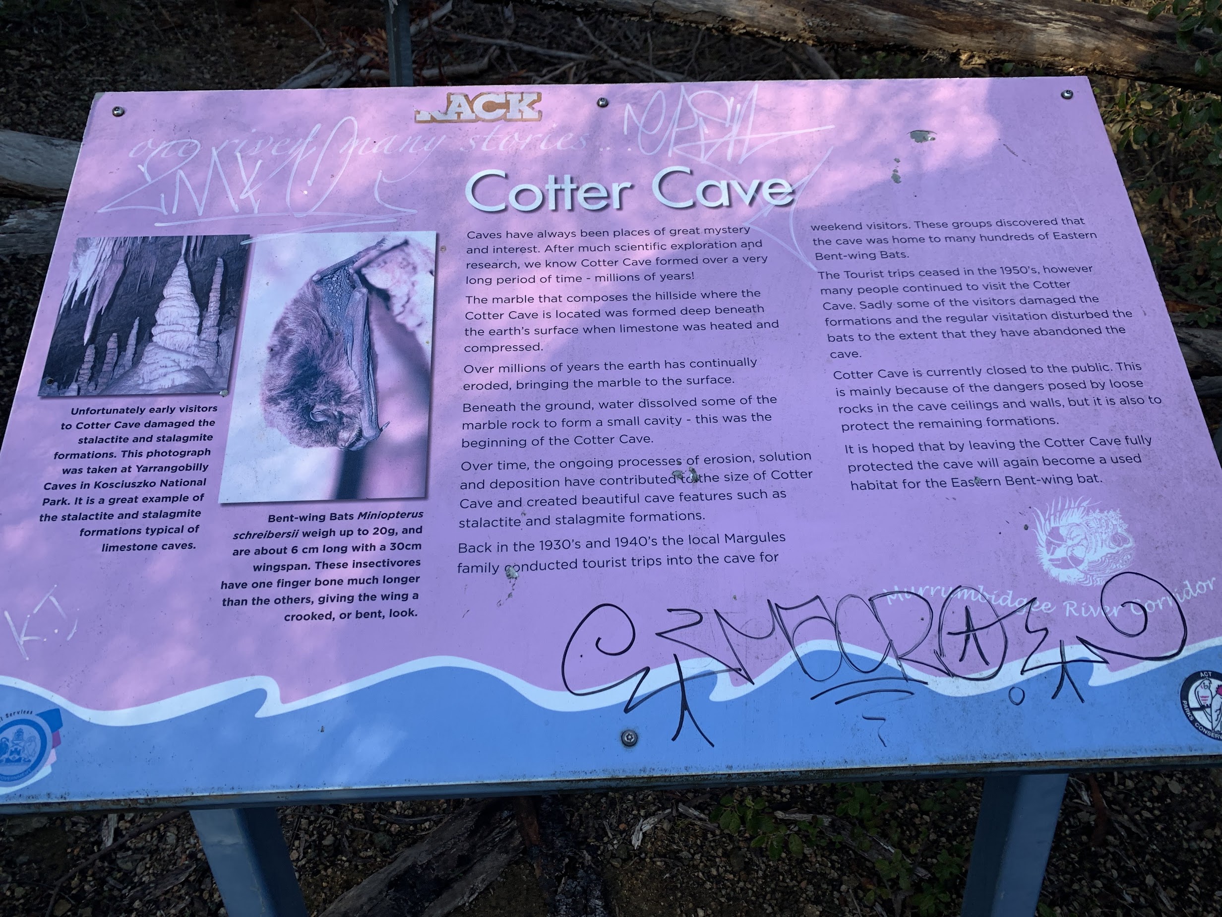
Cotter Cave signage
The track climbs to the barred entrance to Cotter Cave.

Cotter Cave
The lookout is right next to it. Collected the details for GC7N9V8 Cotter Caves & Mines Earthcache.
There are many other Cotter Mine locations in the area, all worth exploring. We didn’t go on today, but I’ve left the waypoints in the gpx file. Check out 6 May 08, 28 Dec 13 and 1 Mar 14 for more deets.
Retraced our steps to near the footbridge.
Walk 2 – Cotter Dam Discovery Trail
We walked along the (concrete) track on the true right side of the Cotter River. A couple of abortive attempts to find geocaches. Passed a couple of weirs.

Weir on Cotter River
A second footbridge took us onto the true left side of the Cotter River and the signage for the Cotter Dam Discovery Trail.

Cotter Dam Discovery Trail signage
I’ve pushed my dear wife in her wheelchair up along here yonks ago. Some great signage. We stopped at the Cotter Spillway Lookout and my good companions searched out the clues for the multi-cache GC2JH44 Cotter Construction II from the numerous signs. Will have to go back for the final GZ.
Down past the old trout hatchery.

Fish hatchery site
Explanatory signage.

Fish hatchery signage
Back down at the Cotter River we crossed again, with great views to the spillway.

Cotter Dam spillway
A pause. Several old Cotter Dam (now 50m underwater) signs.

Original Cotter Dam signage
Walk 3 – Honyong-Cotter Walking Track
The third little hike was up the Honyong-Cotter Walking Track.

Honyong-Cotter Walking Track signage
Halfway up someone (“you’re my favourite”) found geocache GC7CBYG Honyong-Cotter Walking Track for me.
Closer views to the spillway and dam at the top.

Cotter Dam spillway up close
A bonus as we walked along the fence line towards the saddle dam.

7 Emus
Water views from the saddle dam.

Cotter Dam from the saddle dam
At the turn point we stopped for smoko.
Down the hill, my new “favourite” found GCAD9FX Weird Wee Weir for me.
Returned to the River. One of our companions left. We walked back along the Discover Trail to the footpad turnoff to the Grasstree Lookout.
Walk 4 – Moores Hill and CE1 trig
This track took us up to cross Brindabella Road. A bit further on a turn up to the NW to join the trig service road. Up the road to the top. Back down from the service road, a turn to the E then N and we were at the traffic lights at the Murrumbidgee River bridge. Under it and back below the Cotter Camping area. More “favourite” companions found GC6ZQNW Cotter Crossing, GC4WKRQ Possum Guardian 2 and GC4WKRK Barnyard Animals 3 for me.
Lunch by the river. Another walker left.
Walk 5 – Mt McDonald
We drove up Brindabella Road and parked with all the bikies. A good map at the start.

Lower Cotter Catchment Reserve signage at Brindabella Rd carpark
We wandered up the track.

Mt McDonald walking track
Joined the Mt McDonald Road.

Jn Mt McDonald Lookout Track and Mt McDonald Rd
As the sign says, another 1.2km to the top.

Mt McDonald trig
Rather nice views, which I didn’t record.
The nearby ecce.

Mt McDonald ecce (eccentricity)
A short detour on our return to the Lower Cotter Catchment Lookout.

Lower Cotter Catchment Lookout signage
Mick kindly snapped us.
Walkers at Lower Cotter Catchment Lookout (photo Mick S)
Back down at our cars, the back of the map signage held the clues for the multi-cache GC8PEZ6 Mount McDonald’s Kingdom. I’ll have to go back for the final GZs of the two multi-caches.
Walk 6 – Grass Tree Lookout
We drove a few hundred metres down Brindabella Rd and parked on the verge at the Stony Creek Nature Reserve sign.
We could have walked up to this Lookout from the Murrumbidgee River bridge, but it’s easier to walkin around 300m from here at the top.
I love grass trees!

Grass tree at Grass Tree Lookout
Back up to the cars and that was it.
Thanks all. Trust you enjoyed the hike.
The AllTrails map is here, where you can pan and zoom.
Party
12 walkers – Ceilidh A, Cathie B, Andrea C, Mon H, Philippa L, Mark P, Louise R, Lam S, Phillip S, Mick S, Khuong V, me.