North Mundoonen Nature Reserve
Tuesday 7 April: North Mundoonen Nature Reserve – M/M. Change of plan with wet weather forecast. Leader: Jenny H.
5 of us drove in 2 cars to Sheldricks Lane, just off the Hume Highway. Around a 45min drive from our meet point on the Barton Highway near Hall.
Further Information
With a wet day including thunderstorms forecast, Ian W helped Jenny select a walk through woodland and more suited to the weather. Map: Gunning 1:50000; Jerrawa 1:25000.
The Mundoonen Nature Reserve Plan of Management is here.
Summary
Distance: 11.6km | Climb: 435m | Time: 8.50am-1.50pm (5hrs), with 55 mins of breaks | Grading: M/M; M(9)
Track Map
Track

Profile

Photographs
Photographs are available, where you can start a large sized slideshow.
gpx File
Download the .gpx file here. (Right click, Save Link As…, Save – if you want to use it.)
kml File
Download the .kml file here.
Track Notes
I was last in the area on 14 Oct 14.
Patches of blue sky as we drove north, but with the forecast percentage chance of rain at 90%, we knew we’d get damp at some stage.
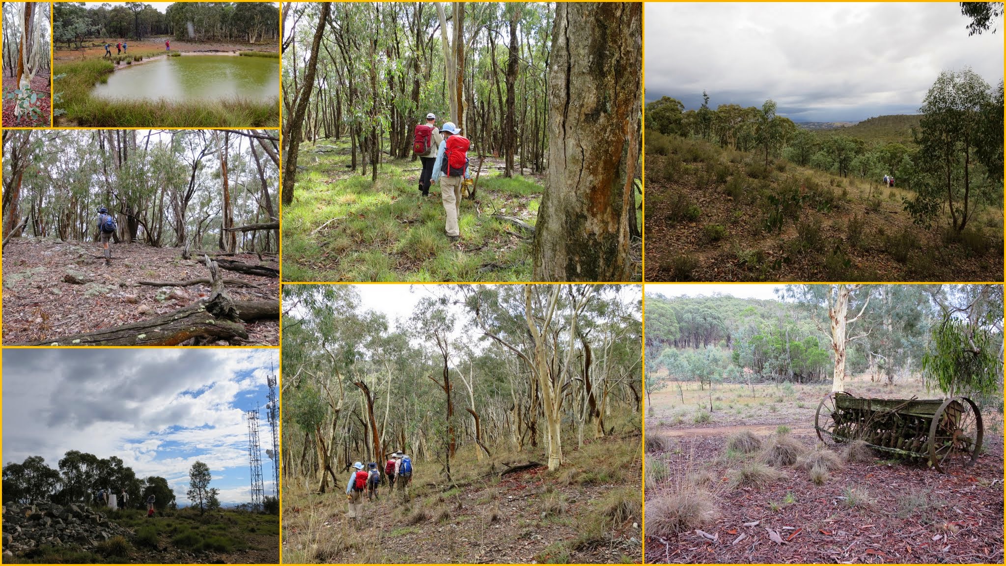
We climbed the Highway Trail service road to the communication towers on Mt Mundoonen. Quite an array of them, including (I presume) the main Sydney-Melbourne microwave link. A fancy NSW trig – white concrete column with a recycled marker on the top at about chest height.
Off-track from here, generally N-ish down a gentle spur clothed in eucalypt woodland. We drifted off the crest (a planned move!) down to the western edge of the southern portion of this area. A few grass trees about. N-ish along the fence line to a corner with a lovely view over open grazing land, then W-ish to the western edge of the NR. A little further N from this corner we found morning tea.
Ominous, loud and long rumblings as we walked N then NE over some higher ground and down to buildings marked on the OZraster Jerrawa 1:25000 map which Ian and I have. A substantial house and associated sheds. Very well watered – 3 large dams nearby and several tanks. Wonder what it was/is/is used for? No mention of it in the Management Plan. However, we made very good use of the verandah as we sheltered for 15 minutes from a savage thunderstorm that rolled over. Always nice to have digital connection on a walk (those huge towers on Mt Mundoonen!), so we could see its extent on the BOM radar. It did go away, but drizzle to rain for the rest of the day.
A bit of a Tasmanian-shaped route followed, N to the NW extent of the walk, SE to a dam then afterwards NE to the NE extent of the walk. Nice view over the surrounding cleared grazing land. Then generally S to lunch on wet logs at about ‘Hobart’.
Our wet weather gear was getting a good workout as we looped over to the west and back, just for the fun of it. Then back onto the Mundoonen Range. Another beautiful group of grass trees. Came off the crest and headed more directly back to the cars.
Great choice for a wet day and a part of Mundoonen Nature Reserve that we hadn’t visited before. Thanks Jen, and Ian for the idea.
Party
5 walkers – Chris F, Eric G, Jenny H (leader), Ian W, me.
Update, from an email 20 Jul 25
Hi John,
Following our NPA walk in Mundoonen Nature Reserve yesterday I thought you might appreciate an update on some of the areas you visited in 2014 and 2015. We used your blog entries from 14 Oct 2014 and 7 Apr 2015 as part of our source material.
We started on the northern side of the highway, and after climbing Mount Mundoonen we headed for the site of the houses and other structures you visited in 2015. We seem to have hugged the north-leading ridge off Mount Mundoonen more than you did, and discovered a number of pits that Terrylea R thought might have been charcoal-related (more about that later) but which we think were related to gold or mineral exploration. I found an 1895 parish map on the National Library website that places much of the Nature Reserve as being in either the “Argyle Camden and King Gold Field” or the “Jerrawa Creek Gold Field” (the map is available here… https://nla.gov.au/nla.obj-231637156/view), so some exploration evidence is not unlikely.
Once we found the house site we noted the absence of… the house! There are still a lot of sheds of various sizes, a clothes line, a possible chook yard, and a large plough (also shown in your 2015 pics) but no house. As we settled down for morning tea a 4WD vehicle arrived, bearing two NSW parks and wildlife rangers and a large tank of weed spray that they intended deploying on the serrated tussock nearby. They explained that the house was demolished and removed about 5 years ago, partly due to it containing asbestos, and that there were no plans to remove the remaining sheds etc. at this stage. It seems the northern part of the nature reserve is the newer side, and the land on which the house etc. stood has been reacquired by the government. There were no issues with us being there.
We took a slightly different route back to the highway and stumbled upon more possible mineral/gold exploration diggings on the lower slopes of Mount Mundoonen, not far from the edge of the reserve. There are probably more.
We crossed the highway and headed for Margules trig via the 1940s charcoal kiln site. I was there a couple of years ago with Lauren O and Jeff B, the former ACT Surveyor-General, and not much has changed. I was able to extract some co-ordinates for the site from my photos from the previous visit – a handy trick! We found the 4 charcoal pits, the steel-rimmed “chimney hole” and a couple of pieces of broken brick from the kilns. A very cool site!
Further up the ridge towards Margules we found a prominent lockspit (easily 5 metres long) that seems to mark part of the boundary between the two gold fields, as well as being on a possible shire boundary. It would also be very close to the current boundary between the localities of Manton and Lade Vale.
After lunch at Margules we headed south and then west in search of the stand of Argyle apple gums you visited in 2014. Along the way we found the Old Gap Road, essentially the original route (1830s?) of what is now the Hume Highway. I’ll head back one day to explore that a bit more.
We found the spot where you waypointed the Argyle apple gums but a lot of them have now fallen down, although there was still quite a few in the vicinity. A very pleasant spot.
We didn’t press on to find the Range/Gap Range trig (the name of the trig seems a bit variable, although “Range” seems to be the official name these days) or the old survey marker you identified in 2014. Interestingly, the 1895 map shows a few such markers along the ridge so that might be something to explore further at some stage too.
In all, a very interesting walk, made more so by the information you have so generously made available. I’ve posted quite a few pics on the ACT Hikers FB page as I am wont to do.
Cheers
Steve G.
Next Tuesday Walk
Tuesday 14 April: Yankee Hat Slabs and Bogong Creek – L/R,ptX. Starting from the Yankee Hat carpark we will ascend to the crest of the Yankee Hat Ridge from near the rock art site. There are excellent granite tors and extensive views at the top. We will then find a route down to Bogong Creek through the extensive slabs on the southwest flank of the ridge. We will then follow Bogong Creek back to the cars. This is a difficult, off-track, exploratory walk. There is thick scrub for most of the day and steep rocky slopes to negotiate. Minimum distance: 16 km with 700 metres of ascent Maps: Rendezvous Creek, Yaouk Leader: Ian W. Transport: 110 km return. Limit: 6.
Tuesday 14 April – no walking for me