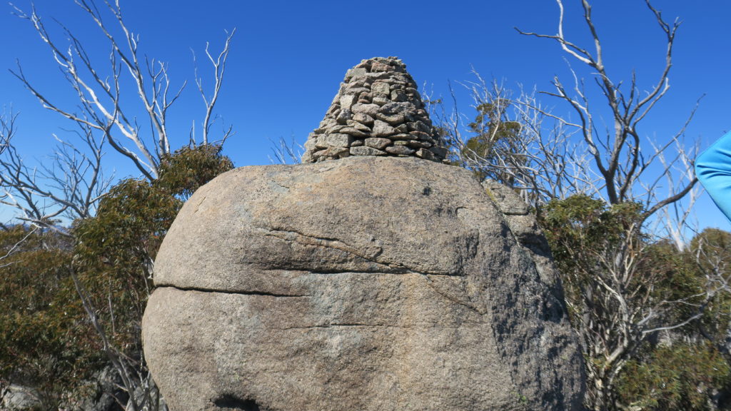
McKeahnie Trig from the west side
Saturday 26 August: McKeahnie Trig – L/R. On track from the Square Rock car park towards Square Rock. A short footpad detour to the Orroral Valley lookout. Backing up a bit, we go bush via a possible aboriginal stone arrangement and through thick regrowth to McKeahnie trig. Our objective is a marvellous rock pile built by Surveyor R C Gordon in 1896. It is thought that ladders were made from saplings to get men and materials up to the difficult site. Back the same way. If there is juice in the tank and desire, we can visit Square Rock. Around 15km, 550m climb and nearly 8 hours. Map: Corin Dam. Leader: John Evans 0417 436 877 john@johnevans.id.au . Transport: ∼$10 per person. Limit: 8. Book by Thursday evening.
Further Information
My previous trips to McKeahnie Trig on 10 Jan 17, 11 Jan 14, 12 Dec 12, 4 Mar 08, 6 Jan 07 and 22 Sep 04. Is it a sign of lassitude and old age that I repeat trips? Could very well be, but on this occasion we had a committed trig-bagger and a Percy-bagger who, at the destination, took his life into his own hands. I’ll go anywhere with such committed walkers!
Summary
Distance: 13.6km | Climb: 540m | Time: 8.05am – 2.40pm (6hrs 35mins), including 65 mins of breaks and 25mins exploring McKeahnie Trig | Grading: M/R; H(12)
Photographs
Photographs are available, where you can start a large sized slideshow.
Waypoint and Track Files
Download the .gpx file. (Right click, Save Link As…, Save – if you want to use it.)
To use in Google Earth, do File, Open… and select Gps or All files as the File Type.
Track Notes
A 7.30am meet opposite my old folks home in the deep south of Canberra. 3 bookees had dropped out, so we had a better sized party for the going. Always a balance between encouraging walkers by giving them a go and the cohesiveness and speed of the whole party. Hats off to one walker who was pretty crook, but wouldn’t have missed the walk for quids.
Walking by 8.05am under blue sky in cool conditions. 4.2km in 1hr 5mins along the Square Rock Walking Track, then along the footpad turnoff to the Orroral Valley Lookout. Reasonable views, a bit of snow lying about, but not enough for a snow-angel. We adjusted clothing and popped on our scrub gloves.
Backing up a couple of hundred metres, we went bush. A 600m leg to a granite slab, guarded by regrowth, which I used to think could be an aboriginal stone arrangement. The rocks seem to grow in a symmetrical ring and there is now a nearby cairn. So no. But a good map spot.
The next leg of 2km took us to McKeahnie trig. 1hr 35mins, including 15mins for morning tea. The going seemed a fraction easier than previously and it was a cohesive and quick moving party. A few animal tracks for a (very) few metres through the regrowth. Came to the sphagnum bog creek top just before the climb to the trig. Open going, but most footsteps sank in. A 100vm climb to the trig, which is guarded by granite tors and Common Shaggy-pea (Oxylobium ellipticum).
I found a watch near the boggy creek top. Still going! Showing the correct date!! Showing the correct (daylight savings) time!!! So it must have been dropped at least before last April. Solar powered. If anyone owns it, please contact me and tell me the make and I’ll begrudgingly happily return it.
We all got to the granite platform on the west side of the trig. Our trig-bagger deserves the claim. There is a geocache near the top of the scramble chute. Great views to the snowy Brindabellas. We retreated, but Jonathan didn’t give up. With rope in hand, we watched him approach from the SE. An anchor around a boulder and a jump (I presume) to a higher level, but no ‘touch the top’ to claim the Percy. I must recommend him to the Percy gate keeper and subtract my point.
Object achieved, lax navigation took us too far to the east off the top. Jared, channeling his pigeon navigation skills, got us back on track. We paused at the morning tea rocks for lunch.
The return seemed scrubbier than going in, but we were pretty much on the inward track, so maybe it’s just due to tiredness. A pause at the open area coming out.
The last 600m to the footpad seemed atrocious but, again, I was weary.
We gave Square Rock a miss today and toddled back down to the cars.
Thanks folks. Great new and old friends. A nice walk on a late winter day, promising things of spring.
Track Maps
Party
7 walkers – Paula F, Jared H, Pete H, Jonathan M, Lauren O, Lisa Q, me.
Justin White
9 September , 2017 4:31 pmHi John – I did this hike with a mate yesterday (8/09/2017) and we found the going very tough through the regrowth. The terrain was good, but the vegetation was horrendous. We did come across a number of animal tracks and I wished they were made by 6-foot tall animals not knee-high ones! Definitely worth getting to the trig point. You can only imagine how difficult it would have been to get all the stones on top of that boulder. We also found two large open granite areas which we also thought may have been made by Aborigines due to the equal distance between the stones in the small circular arrangements. But thanks for the blog which gave me a hike to complete. We won’t be doing this one again until we’ve forgotten about it!!
Justin
Johnny Boy
9 September , 2017 6:42 pmHi Justin. Thanks for letting me know. Agree with all you say about the scrub! Cheers. john