
View from the lookout
Saturday evening 14 September 2024: Urambi Hills Nature Reserve – S/E. A walk up the new Urambi Hill track. Organised by Southern ACT Catchment Group (SACTCG) and Kambah Turns 50 Group. Featured commentary by Ranger Darren Roso and Kambah Historian Glenn Schwinghamer.
Summary
From Garmin Connect (recorded on Epix Gen 2) – Distance: 2.53km | Climb: 115vm | Time: 0:42 moving + 0:58 of stops = 1:40 | Grading: S/E; E(4).
Photographs
View photographs here.
gpx file
Download the gpx file here.
Track Map
Here’s where we went.
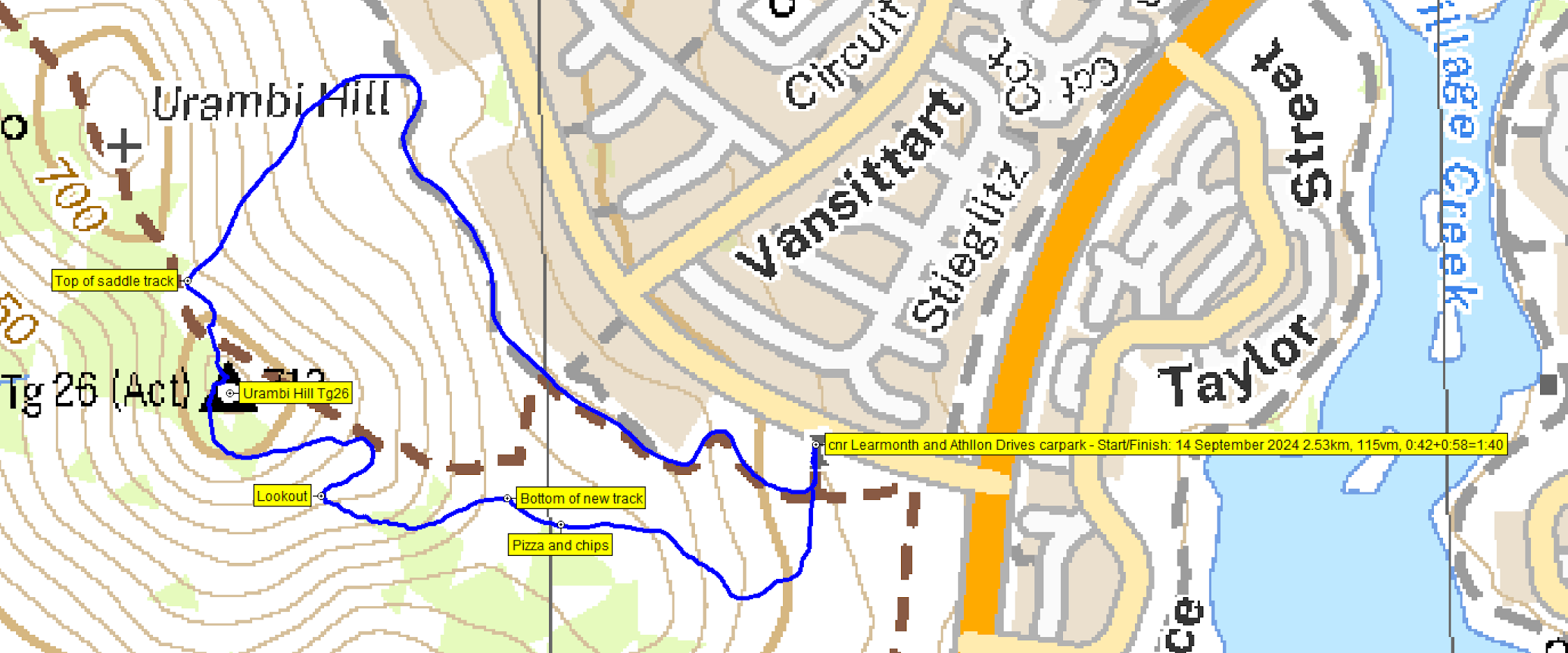
Track Urambi Hills
Trip Report
It is exciting to see so many organisations and people involved in the protection and maintenance of our natural open spaces. Around 20 people attended this event, organised by the Southern ACT Catchment Group and Kambah Turns 50 Group. Ranger of 40 years, Darren Roso, interpretted the land and its maintenance, Glenn Schwinghamer gave us historical snippets, and pizzas and hot chips were shared around near the start of the new track!
After introductory remarks, we headed off.

Urambi Hills Nature Reserve signage
You can gather from the metrics that there were plenty of stops.

Ranger Darren Roso shares information
After a stop for pizza and hot chips, we approached the start of the new track.

Approaching the start of the new track
Plenty of signage to tell us what was going on.

New track open signage
The old track is being rehabilitated.

Old track closed signage
There are some excellent stone steps fire-proofing the track. Darren said the stones came from a quarry at Nimmitabel.

Nice stone steps
I’d heard that the new track alignment provided views. Not disappointed.

View to Mt Tennent from the new track
An excellent lookout a bit higher up.
View from the lookout
The new track ends at the trig. The southerly wind made it frickin’ freezin’. I put on two coats over my two thermals. But a glance of the westering sunset.

Sunset from Urambi Hill
Glenn sensibly suggested that we move to the northern saddle. Ahh – bliss out of the breeze. We descended the fire trail, turned right onto the flank fire trail and ended back at our cars.
Terrific! Thanks all.
Party
~20 walkers.
AllTrails
The AllTrails map is here, where you can pan and zoom.
Johnny Boy’s Walkabout Blog FaceBook Page
I’ve started up a FaceBook page. Each trip report posts to it. It’s another way to get some info to get out and breathe a bit of fresh air. Why not pop over and Follow the page, or give a post a Like.
Additional Trip Reports
As I age, I’m doing a few more simple hikes. I don’t always produce a full trip report. If you’re interested, you can find details of them on the Completed Walks tab. There you can access the trip’s map segment, download a gpx file, see the distance, climb and grading, and link through to the photo album. Additional metrics are available by looking at the start waypoint on the map segment – moving time, stopped time, total time.
Paul
15 September , 2024 11:26 amNotwithstanding a challenging South-Westerly wind, the walk provided an excellent opportunity to experience the new track, which provides magnificent views to the West. Many thanks to Ranger Darren for the informative commentary, to Glenn for the historical insights, to the ladies from ACT Catchment Group for organizing the event and to Little Theos for the pizzas and chips. Finally, a big thanks to John Evans for recording the event on this blog.